
Karakoram (sometimes spelled Karakorum) lies in northeast Pakistan and Northern India, some 1500km west of Nepalase Himalayas and north of westernmost part of Himalaya, separated from it by the river of Indus. It is often regarded as a part of the Himalayas. The mountains in Karakoram typically have sharp, angular form and many of icy peaks are surrounded by wild towers and spires.
Based on geographical features Karakoram can be divided into Greater Karakoram formed by Karakoram main chain running more or less from west to East and northern and southern lesser Karakoram chains on either side of it. Greater Karakoram consists of several Muztaghs and most of the highest and best known peaks are located on this part of the range. For climbers though, probably more meaningful distinction is to use the division based on general location. The following combines the two so that areas are listed generally from West to East and within each area from North to South.
Western Karakoram
Hindu Raj
- Lesser Karakoram, north
- Greater Karakoram
- Lesser Karakoram, south
Lupgar
Lupgar range is located to the north of Batura glacier in NW corner of Karakoram. The mountains lie close to the Wakhan Corridor of Afghanistan with some valleys buffering the border falling in a 'restricted zone'. Most peaks are around 6000m and rock quality is generally very poor. Many 5000m peaks in this area are generally easy to climb and ideal for the first time visitor in Pakistan.
Batura Muztagh
Batura Muztagh forms the westernmost part of Karakoram main chain lying to the west of Hunza valley in Gilgit-Baltistan province of northern Pakistan. Closeness to Karakoram highway make this part easily accessible by Karakoram standards. The area contains some of the Karakoram's highest peaks outside the Baltoro region and some of the most impressive. Most imposing peaks in Passu massif and Batura wall lie to the south of Batura glacier but most ascents have been made from the south. Batura II (7762m) was and Muchu Chhish (7453m) still is among the highest unclimbed peaks in the world, therefore particularly Batura II has seen several suitors.
- West Karakoram Bonanza. The two-man team of Bruce Normand (a Scot residing in Switzerland) and Markus Walter from Germany made a series of attempts and ascents in the Western Karakoram of Pakistan this past summer. The pair began with an unsuccessful attempt on Batura II (7762m), one of six high points on part of the watershed ridge separating the Batura Glacier to the north from the Hunza valley to the south. By Lindsay Griffin at Alpinist on 2006-10-17.
Kampire Dior group
Group of peaks rising in a horseshoe form around the end of Baltoro glacier. The highest peak is Kampe Dior with several other peaks either a little over or just below 7000m. The best known climbs of the area are Kampe Dior and Beka Brakai Chhok, both of whic have been visited by few parties. Other than that, not much information about the climbing is available. Of the unclimbed objectives, particularly North Face of Kuk Sar II is highly impressive.
Batura group
Batura peaks lie on Batura Muztagh main chain in NW-SE direction forming long continuous ridge known as Batura Wall. The order of peaks starting from North is IV, III, II, I, V (Muchu Chhish) and VI (Far East). The group has a major side ridge toward NE from III and one towards SW from II (Hachindar Chhish). Another prominent ridge drops towards South from Muchu Chhish. Huge north face is well visible from Baltoro glacier, but there have been remarkably few attempts from this side. South side climbs west if SW ridge of Bature II start from Baltar glacier while the ones on its east side start from Muchuchar glacier. The ridge can be crossed at Batokshi Col (~6000m) thus some of the routes on Batura I and II can be started from either of the valleys.
- Batura I, 7794 m (Batura II, III, IV). Erkundung, Erstbesteigung, Erstbegehungen, Ereignisse. By Günter Seyfferth at Die Berge des Himalaya.
Pasu group
Peaks located on the ridge branching towards (N)E from Barura main chain on Pasu Sar, while SE chain consists of Shispare - Ultar Sar. Peaks are high and fairly accessible via Batura glacier (north side) or Pasu glacier (south side), yet not a lot information about climbs or attempts on the peaks can be found.
Atabad group
Southwestern cluster of peaks on Batura main ridge. The peaks are located close to Karimabad and Karakoram highway. The highest peak of the group is Ultar Sar with Bojohagur Duanasir and Hunza Peaks being the other main peaks of the area. Furthermore sharp pinnacles of Ladyfinger Peak (Bublimating) and Gulmit Tower are aesthetic peaks providing technical climbs. Very few successful ascents have been made in the peaks, therefore lots of room for new routes. The main goal of the area is SE spur of Ultar Sar that has been attempted several times by strong parties, so far without success.
Hachindar Chhish
Hachindar Chhish is the principal peak on the long chain branching SW from main chain at Batura II. Not much information about the climbs, but based on the first ascent party reporting to have aided several pitches and pictures of the peak, it seems safe to assume that all the possible routes are technical. Gutum Talji and Pute Towers are the other main features of the group.
- American Alpine Journal, year: 1982, isbn: 9780930410155, pp: 279.'Thaime Chhish, Batura Region Attempt' by John Nixon.
- American Alpine Journal, year: 1984, isbn: 9780930410230, pp: 303.'Sia Chhish, Batura Group' by Giorgio Mallucci.
Kampire Dior group
- American Alpine Journal, year: 1976, isbn: 9780930410735.
- American Alpine Journal, year: 1978, isbn: 9780930410742.
| 1986-08-03 | Pamri Sar I, , First ascent | Party from It |
| 1991-07-29 | Sani Pakkush, , First ascent | Hubert Bleicher |
| 1982-07-19 | Kuk Sar I, , First ascent | Party from UK |
- Beka Brakai Chhok NE (6845m)
- Beka Brakai Chhok Central (6882m36.55055555674.430555556)
- Beka Brakai Chhok South (6850m)
| 2008-01-01 | Beka Brakai Chhok, , First ascent | Herve Barmasse, Simone Moro |
| 2008-01-01 | Beka Brakai Chhok, South ridge, First ascent | South ridge: Herve Barmasse & Simone Moro |
- Beka Brakai Chhok and Simone Moro. In March of this year, news sites on the internet created controversy based on a writer who claimed to know that Simone Moro was aware he did not climb the highest of the three Beka Brakai Chhok peaks. By Eberhard Jurgalski at 8000ers.com on 2009-08-11.
- History and Details from Beka Brakai Chhok. Italians Herve Barmasse and Simone Moro have made the first ascent of Beka Brakai Chhok (6940m), a high and imposing snow and ice peak in the Karakoram's Batura Group. The ascent and descent were completed in an impressive 43-hour alpine-style attempt with very minimal bivouac equipment, the pair overcoming exposed, poorly protected and delicate sections of hard climbing. By Lindsay Griffin at Alpinist on 2008-08-11.
- American Alpine Journal, year: 2009, isbn: 9781933056098, pp: 264-266.
- Beka Brakai Chhok summit by Moro and Barmasse. On 1 August 2008 Italian mountaineers Simone Moro and Herve Barmasse reached the hitherto unclimbed summit of Beka Brakai Chhok (6940m) in Pakistan's Karakorum. By PlanetMountain at Planet Mountain on 2009-08-11.
- Simone Moro - Batura II Expedition 2008. At flickr.
| 1984-08-04 | Seiri Porkush, , First ascent | Party from UK |
Batura group
| 1976-01-01 | Batura Sar, Baltar route, First ascent | Baltar route: Hubert Bleicher & Herbert Oberhofer |
| 1976-06-30 | Batura Sar, , First ascent | Hubert Bleicher & Herbert Oberhofer |
| 1983-01-01 | Batura Sar, Muchuhar route, First ascent | Muchuhar route: Austrian expedition |
| 1954-08-05 | Sarbzea Sar, , First ascent | Party from Ger |
| 1983-08-31 | Batura IV, South face, First ascent | South face: Zygmunt A. Heinrich, Pawel Mularz, & Volker Stallbohm |
- American Alpine Journal, year: 1984, isbn: 9780930410230, pp: 303.'Batura IV' by Józef Nyka.
| 2008-08-11 | Batura II, South face, First ascent | South face: Kim Chang-ho & Choi Suk-mun |
- West Karakoram Bonanza. The two-man team of Bruce Normand (a Scot residing in Switzerland) and Markus Walter from Germany made a series of attempts and ascents in the Western Karakoram of Pakistan this past summer. The pair began with an unsuccessful attempt on Batura II (7762m), one of six high points on part of the watershed ridge separating the Batura Glacier to the north from the Hunza valley to the south. By Lindsay Griffin at Alpinist on 2006-10-17.
- Simone Moro. Batura II, 7762 m. Batura II, 7762 meters, represents the highest unclimbed mountain on this earth. The southern face of Batura II, the side which will be the object of our attempt, is definitely more difficult but less dangerous compared to the western face. It is the same face on which previous attempts were made, but which we will attempt by following a new and different line from what has been followed up until now. At Mountain.ru.
- Simone Moro - Batura II Expedition 2008. At flickr.
- Moro and Ogwyn summit Batokschi, but abandon Batura II. After having reached the summit of Batokschi (6050m) via a new route Simone Moro and Joby Ogwyn's adventure on Batura II (7762m Pakistan - Karakorum), the highest still unclimbed peak in the world, has come to an abrupt end. By PlanetMountain at Planet Mountain on 2005-07-11.
- Batura Muztagh Expedition 2006. Bildergalerie Teil 1 - Versuch am Batura II. At Alpinclub Sachsen.
- American Alpine Journal, year: 2006, isbn: 9781933056012.
- American Alpine Journal, year: 2009, isbn: 9781933056098, pp: 262-264.'Batura II (7,762m), First Ascent' by Christine Pae.
Pasu group
| 1974-07-21 | Shishpare, , First ascent | H. Bleicher, L. Cichy, M. Grochowski, J. Holnicki-Szulc, A. Mlynarczyk, H. Oberhofer & J. Poreba |
| 1974-07-21 | Shishpare, East ridge, First ascent | East ridge: H. Bleicher, L. Cichy, M. Grochowski, J. Holnicki-Szulc, A. Mlynarczyk, H. Oberhofer & J. Poreba |
- American Alpine Journal, year: 1975, isbn: 9780930410728.
- American Alpine Journal, year: 1990, isbn: 9780930410438.
- American Alpine Journal, year: 1995, isbn: 9780930410612.
| 1994-08-07 | Pasu Sar, , First ascent | Max Wallner, Dirk Naumann, Ralf Lehmann & Volker Wurnig |
- American Alpine Journal, year: 1995, isbn: 9780930410612.
- American Alpine Journal, year: 2002, isbn: 9780930410919.
| 1974-07-21 | Ghenta Sar, , First ascent | Party from Pl |
- West summit (7500m)
- East summit (7284m)
- American Alpine Journal, year: 1979, isbn: 9780930410759, pp: 306.'Passu Peak'
Atabad group
| 1996-07-11 | Ultar Sar, , First ascent | Akito Yamazaki & Kiyoshi Matsuoka |
| 1996-07-11 | Ultar Sar, SW face, First ascent | SW face: Akito Yamazaki & Kiyoshi Matsuoka |
| 1996-07-21 | Ultar Sar, South ridge, First ascent | South ridge: Ken Takahashi, Masayuki Ando, Ryushi Hoshino, Waltaru Saito & Nobuo Tsutsumi |
- American Alpine Journal, year: 1992, isbn: 9780930410513.
- Alpine Journal, year: 1993, pp: 49-54.'We failed on Ultar' by Victor Saunders.
- American Alpine Journal, year: 2012, isbn: 9781933056753, pp: 251.'Ultar (Ultar Sar, 7,388m), Southeast Pillar Attempt' by Hiroshi Hagiwara.
- Mountain Info, #503 issue: 21, date: 2006-11.
- American Alpine Journal, year: 1997, isbn: 9780930410711, pp: 310.'Ultar Sar, First Ascent' by Jozef Nyka.
- First Ultar II ascent and tragedy, 1996. By Noboru Onoe at Japanese Alpine Journal.
- American Alpine Journal, year: 1991, isbn: 9780930410469.
- American Alpine Journal, year: 1997, isbn: 9780930410711, pp: 310.'Ultar Sar, First Ascent' by Jozef Nyka.
| 1984-07-28 | Bojohagur Duan Asir, , First ascent | Party from Jp |
- American Alpine Journal, year: 2008, isbn: 9781933056074, pp: 252-253.'Gulmit Tower (5,810m), southeast ridge, attempt' by Slawomir Kawecki.
| 1991-01-01 | Hunza Peak, SW ridge, First ascent | SW ridge: Mick Fowler & Caradog Jones |
| 1982-05-22 | Ladyfinger Peak, East ridge, First ascent | East ridge: Patrick Cordier & Jacques Mauri |
| 1995-08-24 | Ladyfinger Peak, SW face, First ascent | SW face: Yasushi Yamanoi, Daisaku Nakagaki & Taeko Nagao |
- +Belles pp.112
- American Alpine Journal, year: 1983, isbn: 9780930410216.
Hachindar Chhish
| 1984-07-11 | Sang-e-Marmar, , First ascent | Party from Jp |
| 1982-01-01 | Hachindar Chhish, SE face, First ascent | SE face: Japanese party |
| 1982-08-04 | Hachindar Chhish, , First ascent | Party from Jp |
- American Alpine Journal, year: 1979, isbn: 9780930410759, pp: 306.'Hachindar Chhish Attempt'
- American Alpine Journal, year: 1983, isbn: 9780930410216, pp: 281.'Hachindar Chhish, East Face' by Kiyoshi Hayami.
| 1982-01-01 | Hachindar Chhish, SE face, First ascent | SE face: Japanese party |
- American Alpine Journal, year: 1979, isbn: 9780930410759, pp: 306.'Hachindar Chhish Attempt'
- American Alpine Journal, year: 1983, isbn: 9780930410216, pp: 281.'Hachindar Chhish, East Face' by Kiyoshi Hayami.
| 1996-01-01 | Pute Tower III, East face & South ridge, First ascent | East face & South ridge: Pete Thompson, Johannes Gouws, Tom Goodwin, Pete Scott & Sam Stacey |
Naltar
Naltar valley lies in the NW of Gilgit surrounded by the peaks of Naltar mountains. The range is low by Karakoram standards with none of the peaks reaching 6000m. Sentinel (5260m) and Shani peak (5887m) are likely most climbed peaks of the range. Sentinel is a moderately difficult alpine climb, while Shani peak is a serious mixed rock and I snow climb.
- American Alpine Journal, year: 1989, isbn: 9780930410391, pp: 264.'Shani Attempt and Ascents of Other Peaks, Naltar Valley, Western Karakoram' by Stephen Thompson.
- American Alpine Journal, year: 1990, isbn: 9780930410438, pp: 296.'Shani, Naltar Valley' by Peter Leeming.
- American Alpine Journal, year: 2000, isbn: 9780930410872, pp: 327.'Naltar Mountains, Shani Peak, Various Ascents' by Elwin van der Gragt.
- American Alpine Journal, year: 2001, isbn: 9780930410896, pp: 148.'The Karakoram, Whatever Your Game, The Karakoram Has It' by Stephen Venables.
- Shani Peak
- Shani Peak East (5610m)
| 1986-01-01 | Shani Peak, West ridge, First ascent | West ridge: Roger Everett & Guy Muhlemann |
| 1999-08-22 | Shani Peak, NE Spur, First ascent | NE Spur: Andreas Amons & Melvin Redeker |
| 1999-08-30 | Shani Peak, SE face, Dutch route, First ascent | SE face, Dutch route: Elwin van der Gragt & Benno Netelenbos |
- Alpine Journal, year: 1991, pp: 62-68.'Shani, South-East Face' by Peter Leeming.
- American Alpine Journal, year: 1989, isbn: 9780930410391.
- American Alpine Journal, year: 1992, isbn: 9780930410513.
- American Alpine Journal, year: 2002, isbn: 9780930410919.
- Shani Peak -c5,800m- (Naltar valley). By Melvin Redeker.
- American Alpine Journal, year: 2000, isbn: 9780930410872, pp: 327.'Shani Peak, Various Ascents' by Elwin van der Gragt.
- American Alpine Journal, year: 2000, isbn: 9780930410872, pp: 327.'Shani Peak, Various Ascents' by Elwin van der Gragt.
- American Alpine Journal, year: 1987, isbn: 9780930410292.'Shani, Naltar valley' by Roger D. Everett.
Northern Karakoram
Ghujerab Mountains
Despite being visible to Karakoram highway, Ghujerab areas are not too popular among foreign climbers. Lack of really famous peaks is certainly one reason for that, the reportedly appalling rock quality without a doubt another. The highest peak of the area is Karun Koh (7164m). The most accessible part of the range is Tupopdan and the entire cathedral ridge, both of which are visible from Karakoram Highway.
Main access to Ghujerab Mountains is from Shimshal valley. The valley apparently has strong mountaineering tradition and several Pakistani climbers who have climbed the high peaks of the country come from the valley. Therefore no reason to expect the peak to be unclimbed if no reports can be found on the usual sources.
Tupopdan
The group located on the east side of Hunza valley and Karakoram highway, NE of Passu and more or less opposite Batura glacier. The highest peak of the group is Tupopdan (6106m, also known as "Passu Cones" or "Passu Cathedral"). Other than that the whole Cathedral ridge is full of sharp rock summits.
North Ghujerab
North Ghujerab mountains are located between Khunjerab valley in the north ans Ghujerab valley in the south. Jerzy Wala map does not name any other mountains but there are several peaks above 6000m. The highest peak is Charchingal Sar (6483m). At least Koksil Sar has been visited by climbers.
- American Alpine Journal, year: 2012, isbn: 9781933056753, pp: 245-246. By Janusz Majer.
- American Alpine Journal, year: 2012, isbn: 9781933056753, pp: 247.'Koksil Sar I (6,176m, Polish Map; 6,152m GPS), west flank and northwest ridge; Koksil Sar II (5,909m GPS), west ridge; Koksil Sar III (5,888m GPS), southeast flank' by Markus Gschwend.
- http://jac.or.jp/english/images/JAPANESE%20ALPINE%20NEWS%20Vol13-48.pdf Koksil Valley - Ghujerab mountains Japanese Alpine News
South Ghujerab
South Ghujerab mountains are located between Ghujerab valley in the north ans Shimshal valley in the south. The highest peak of the group is Karun Koh. Jerzy Wala map does not name any other mountains but there are several peaks above 6000m.
Central Karakoram
All of the most famous peaks in Karakoram are located in Central Karakoram, that contains Hispar, Panmah and Baltoro Muztaghs in the Greater Karakoram. Baltoro has all four 8000m peaks in Karakoram, as well as famous rock spires of Uli Biaho, Trango and Muztagh Towers. Panmah is home to Ogre and Latok groups, both having host of the most coveted unclimbed lines. Also southern Lesser Karakoram has some very impressive peaks like Rakaposhi and Masherbrum range. Particularly the latter has become popular as several parties have visited Charakusa and Nangma valleys around Hushe.
- Lesser Karakoram, north
- Greater Karakoram
- Lesser Karakoram, south
Wesm/Yengisogat
Wesm range (also known as Yengisogat), is a Chinese (Xinjiang Uygur Autonomous Region) subrange of the Karakoram, located due north of Baltoro Muztagh. The highest peak is Huangguan Shan (Crown Peak) at 7265m. Not well known range among the climbers.
Insgaiti Muztagh
Crown group
| 1993-07-22 | Huang Guan Shan, , First ascent | Akito Yamasaki, Yasuyuki Aritomi & Kazuo Tokushima |
| 1993-07-22 | Huang Guan Shan, East face, First ascent | East face: Akito Yamasaki, Yasuyuki Aritomi & Kazuo Tokushima |
- American Alpine Journal, year: 1988, isbn: 9780930410339, pp: 286.
- American Alpine Journal, year: 1991, isbn: 9780930410469, pp: 301.
- American Alpine Journal, year: 1994, isbn: 9780930410582, pp: 280.'The Crown (Huang Guan Feng)' by Kazuo Tokushima.
Hispar Muztagh
Hispar Muztagh is located in the Gojal region of Pakistan, north of Hispar Glacier, south of Shimshal Valley, and east of the Hunza Valley. The chain south of Hispar glacier with numerous 6000m peaks is not part of Hispar Muztagh, it belongs to Lesser Karakoram. Hispar is the second highest sub-range of the Karakoram after Baltoro Muztagh. Aside of 8000m peaks in Baltoro, the highest peaks of Karakoram are located in Hispar Muztagh, with Distaghil Sar (7885m), Kunyang Chhish (7852m) and Kanjut Sar (7760m) being the highest. The area is not part of the restricted border zone. Despite of this, the area is not very often visited by climbers.
- Mountain Info, #513 issue: 31, date: 2007-09.
- American Alpine Journal, year: 2009, isbn: 9781933056098, pp: 269-271.
- Hispar Muztagh. At American Alpine Journal.
- Hispar Muztagh. At Alpine Journal.
- The Hispar Muztagh, Pakistan. The Hispar Muztagh is a sub-range of the mighty Karakoram mountains. It lies on the north side of the Hispar glacier, Pakistan's fifth largest glacier and certainly one of the most impressive. To the north of the Hispar Muztagh is the Shimshal valley, named after the village at the heart of the region. The range contains numerous 7000m+ peaks, some of which remain unclimbed with many only having been ascended once. By BigLee at SummitPost on 2007-01-31.
Momhil group
Westernmost mountains in Hispar Muztagh. Several 7000m peaks, yet the peaks are seldom climbed.
Disteghil group
Northern group on the Central Hispar Muztagh. The peaks are connected with Momhil group by a high ridge, so these two groups are not really separated. Distaghil Sar, the highest peak of entire Hispar Muztagh, is located in this group. Other than that Malangutti Sar and Yazghil Domes are the other main peaks.
Yazghil group
Southern group of Central Hispar Muztagh. The peaks are located close to Biafo glacier and not very remote by Karakoram standards. Very few ascents on any of the peaks. Khunyang Chhish East got attention from elite climbers as it was among the highest unclimbed peaks until Simon Anthamatten and Auer brothers climbed it in 2013.
Khunyang Chhish lies in the heart of the Hispar Muztagh, north of the Hispar Glacier, one of the major glaciers of the Karakoram, and actually it location is in Skardu District of Baltistan. It rises on the southwest side of the Khunyang Glacier while Distaghil Sar (the highest peak of the Hispar Muztagh) dominates the glacier on its northern end.
- Kunyang Chhish, 7852m. Erkundung, Erstbesteigung, Erstbegehungen, Ereignisse. By Günter Seyfferth at Die Berge des Himalaya.
- American Alpine Journal, year: 1975, isbn: 9780930410728, pp: 215.
- American Alpine Journal, year: 2010, isbn: 9781933056234, pp: 264.'Pumari Chhish East, Attempt; Rasool Sar, First Ascent; 'Lunda Sar,' First Ascent of Southwest Face (No Summit); Khani Basa Sar, First Ascent' by Raphael Slawinski.
Kanjut group
Groups to the east of Yazghil and Yutmary glaciers and to the west of Khundopin glacier. There being several high peaks, particularly Kanjut and Yukshin Gardan Sar. The peaks are furthest away road ends of all of Hispar Muztagh which is certainly one reason why the peaks are little explored.
Momhil group
| 1960-08-17 | Trivor Sar, , First ascent | Wilfrid Noyce & Jack Sadler |
| 1960-08-17 | Trivor Sar, NW ridge from South, First ascent | NW ridge from South: Wilfrid Noyce & Jack Sadler |
| 1991-08-30 | Trivor Sar, NW ridge from north, First ascent | NW ridge from north: Toshifumi Onuki & Atsushi Endo |
- Berge der Welt Berge der Welt 1960/61
- American Alpine Journal, year: 1992, isbn: 9780930410513, pp: 252.'Trivor Ascent and Momhil Sar Attempt' by Toshifumi Onuki.
| 1964-06-29 | Momhil Sar, , First ascent | Party from A |
| 1964-06-29 | Momhil Sar, SE side, First ascent | SE side: Hanns Schell, Rudolph Pischinger, Horst Schindelbacher, Leo Schlömmer & Rudolf Widerhofer |
- American Alpine Journal, year: 1965, pp: 475.'Momhil Sar' by Eric Goodwin.
- Peak 7010 (Lupghar Sar West II) (7010m)
- Lupghar Sar West (7200m36.34833333375.025833333)
- Lupghar Sar Central (7201m36.34833333375.025833333)
- Lupghar Sar East (Lupghar Sar) (7200m36.34833333375.025833333)
| 1979-06-01 | Lupghar Sar, West, First ascent | West: Austrian party |
| 1979-06-01 | Lupghar Sar, West, First ascent | West: Japanese party |
| 1979-08-04 | Lupghar Sar, , First ascent | Party from Jp |
- American Alpine Journal, year: 1987, isbn: 9780930410292.
- American Alpine Journal, year: 1980, isbn: 9780930410766, pp: 650.'Lupghar Sar West' by Hans Gloggner.
- American Alpine Journal, year: 1995, isbn: 9780930410612, pp: 292.'Lupghar Sar East Attempt and Ascents of Dut Sar and Chikkorin Sar, 1993' by Giacomo Scaccabarozzi.
- Alpine Journal, year: 2000, isbn: 9780948153624, pp: 266.'Pakistan 2000' by Lindsay Griffin.
| 1990-07-25 | Bularung Sar, , First ascent | Party from CH |
Disteghil group
- West (7885m36.32583333375.188333333)
- Central (7760m)
- SE (7535m)
| 1960-06-09 | Disteghil Sar, , First ascent | Günther Stärker & Diether Marchart |
| 1960-06-09 | Disteghil Sar, South face & SW ridge, First ascent | South face & SW ridge: Günther Stärker & Diether Marchart |
- American Alpine Journal, year: 2009, isbn: 9781933056098.
- Disteghil Sar, 7885 m. Erkundung, Erstbesteigung, Erstbegehungen, Ereignisse. By Günter Seyfferth at Die Berge des Himalaya.
- American Alpine Journal, year: 2009, isbn: 9781933056098, pp: 272-273.
- 2008 UK/Canadian Distaghil Sar Expedition. The expedition was not successful in its declared aim of climbing Distaghil Sar from the north. The major conclusion which can be drawn is that conditions are changing very rapidly in the world’s mountains, even at the very highest altitudes. That 10-year-old information could be badly out of date is in fact familiar to climbers in the Alps (due mainly to the effects of summer 2003), and this situation can now be taken to be true also in parts of the Greater Ranges. By Bruce Normand at Himalayan Club on 2008.
- Alpine Journal, year: 1961.'Distaghil Sar (25,868 ft.)' by Wolfgang Stefan.
- American Alpine Journal, year: 1983, isbn: 9780930410216, pp: 280.'Distaghil Sar, Second Ascent' by Joaquim Prunés.
- American Alpine Journal, year: 1992, isbn: 9780930410513, pp: 280.'Distaghil Sar Attempt' by Jean-Luc Ginhoux.
- Himalayan Journal, year: 1958.'Disteghil Sar' by Dennis Davis.
| 1983-07-28 | Yazghil Dome, , First ascent | Ryszard Kowalewski, Andrzej Bielun, Dr. Jacek Gronczewski, Tadeusz Piotrowski & Jerzy Tillak via SW face |
| 1985-08-12 | Malangutti Sar, , First ascent | Y. Muranaka, K. Nakahara, T. Sugimoto & A. Nima |
Yazghil group
| 1971-08-26 | Kunyang Chhish, , First ascent | Party from Pl |
- Mountain Info, #513 issue: 31, date: 2007-09.
- Himalayan Journal, year: 1971.'Khinyang Chhish climbed' by Andrzej Kus.
| 2013-07-18 | Kunyang Chhish East, SW face, First ascent | SW face: Simon Anthamatten, Matthias Auer & Hansjörg Auer |
- American Alpine Journal, year: 2014, isbn: 9781933056838.'Khunyang Chhish East' by Hansjörg Auer.
- Swiss-Austrian Trio Solves Technical Face in Kunyang Chhish Massif. Swiss alpinist Simon Anthamatten and Austrian brothers Matthias and Hansjoerg Auer topped the unclimbed summit of Kunyang Chhish East (ca. 7400m) in the Karakoran's Hispar Muztagh. Their line of ascent, finally established after three attempts, bisects the 2700m southwest face, compared in size and technical grade to the famously difficult North Face of Jannu by the Polish climber Grzegorz Skorek during his 2003 attempt. By David Crothers at Alpinist on 2013-08-14.
- Piolets d'Or Nominates Five Ascents. The Jury of the 22nd edition of the Piolets d'Or—comprising Catherine Destivelle, Erri de Luca, Karin Steinbach, Sung-Muk Lim, Denis Urubko, together with this year's president George Lowe—had the difficult task of selecting those ascents from 2013 that represent the state of the art in mountaineering today. By Piolets d'Or at Alpinist on 2014-02-27.
- Kunyang Chhish East, Karakoram: first ascent by Simon Anthamatten, Hansjörg Auer and Matthias Auer. On 18 July 2013 Simon Anthamatten from Switzerland and the Austrian brothers Hansjörg Auer and Matthias Auer successfully climbed the hitherto virgin peak Kunyang Chhish East in Pakistan's Karakorum. By PlanetMountain at Planet Mountain on 2013-07-23.
| 1979-07-11 | Kunyang Chhish North, , First ascent | Party from Jp |
Pumari Chhish
| 1979-06-12 | Pumari Chhish, North ridge, First ascent | North ridge: S. Chiba, K. Minami, M. Ohashi & H. Yokoyama |
| 1979-07-15 | Pumari Chhish, , First ascent | S. Chiba, K. Minami, M. Ohashi & H. Yokoyama |
- American Alpine Journal, year: 1980, isbn: 9780930410766, pp: 649.'Pumari Chhish' by Takao Sasaki.
| 2007-06-12 | Pumari Chhish South East, , First ascent | Yannick Graziani & Christian Trommsdorff |
Kanjut group
Kanjut Sar group
| 1959-06-19 | Kanjut Sar I, South ridge, First ascent | South ridge: Camillo Pellissier |
| 1959-07-19 | Kanjut Sar I, , First ascent | Camillo Pellissier |
| 1981-08-04 | Kanjut Sar I, West face, First ascent | West face: Japanese party |
- American Alpine Journal, year: 1960, pp: 161.'Kanjut Sar'
- Mountain Info, #490 issue: 8, date: 2005-10.
- American Alpine Journal, year: 1982, isbn: 9780930410155, pp: 276.'Kanjut Sar, West Face' by Masayoshi Fujii.
- Alpine Journal, year: 1984, pp: 179-180.'Kanjut Sar West Face' by Masayoshi Fujii.
| 1985-07-10 | Kanjut Sar II, , First ascent | Party from CH |
- American Alpine Journal, year: 1991, isbn: 9780930410469, pp: 268-270.'Kanjut Sar II' by Peter Kok.
- American Alpine Journal, year: 1986, isbn: 9780930410278, pp: 282.'Kanjut Sar II' by Toni Spirig.
- Mountain Info, #490 issue: 8, date: 2005-10.
| 1900-01-01 | Hispar Sar, , Event | Simon Yates, Andy Parkin (to south ridge) Doug Chabot, Bruce Miller, Steve Su |
- Mountain Info, #490 issue: 8, date: 2005-10.
- Alpine Journal, year: 2005, pp: 96-102.'Nought but Noodles on Hispar Sar' by Simon Yates.
- American Alpine Journal, year: 2009, isbn: 9781933056098, pp: 271-272.'Hispar Sar, attempt; Emily Peak (Point 5,684m), first ascent.' by Rufus Duits,.
- American Alpine Journal, year: 2012, isbn: 9781933056753, pp: 253-255.'Hispar Sar (6,400m), Southwest Face' by Doug Chabot.
- Americans Bag Much-Tried Hispar Sar. American climbers Doug Chabot, Bruce Miller, and Steve Su completed the first ascent of Hispar Sar (6,400m/20,997') in the Karakoram of Pakistan in early August. At Climbing Magazine.
| 1977-07-01 | Tahu Rutum, SW ridge, First ascent | SW ridge: Kazuya Mitsumoshi, Kazuto Obata, Yoshinobu Tanaka & Yukio Usagawa |
- American Alpine Journal, year: 2009, isbn: 9781933056098, pp: 269.'Tahu Rutum, West Face, Solo Attempt' by Kyle Dempster.
- Young team receives 2010 Nick Estcourt Award. University students Hamish Dunn, Luke Hunt and Tom Ripley have been given the 2010 Nick Estcourt Award for their attempt on the unclimbed North West Ridge of Tahu Rutum (6,651m) in Pakistan. By Lindsay Griffin at The British Mountaineering Council on 2010-01-20.
- American Alpine Journal, year: 1978, isbn: 9780930410742, pp: 624.'Tahu Rutum, Biafo Karakoram' by Nobuo Kuwahara.
Yazghil Sar-Yutmaru Sar
| 1984-06-26 | Yukshin Gardan Sar, , First ascent | Party from A |
- American Alpine Journal, year: 1985, isbn: 9780930410247, pp: 322.'Yukshin Gardan Sar, First Ascent' by Rudolf Wurzer.
- American Alpine Journal, year: 1987, isbn: 9780930410292, pp: 288.
- American Alpine Journal, year: 2009, isbn: 9781933056098, pp: 271-272.
Panmah Muztagh
Panmah Muztagh lies in the heart of Karakoram in Baltistan District of Pakistan. Peaks of the area are not particularly high by Karakoram standards, the highest being Baintha Brakk (The Ogre, 7285m). However, what they lack in height, they more than make up for grandeur. This area is home to particularly wild and exceedingly steep rock spires offering no easy way up. Baintha Brakk has only been climbed thrice (by 2014), each time by world class teams. First ascent is famous for epic as Doug Scott broke both ankles close to summit and Chris Bonington broke two ribs and contracted pneumonia. Second ascent took 24 years and 25 failed attemps. Another highlight of the area is Latok group, the ascents on which are of similar difficulty.
Ogre and Latok groups aside, not much is known about the peaks on Panmah. The long chain to the north of Chocktoi glacier contains Biacherahi Towers, at least some of which have been climbed. Still further north, a chain of peaks runs generally from west to east. The chain has several peaks above 6000m high, but no real giants or famous peaks. The main peaks of this chain are Braldu Brakk, Lupke Brakk and Bobisghir.
- Panmah Muztagh. Articles on AAJ. At American Alpine Journal.
- Panmah Muztagh. Articles on AJ. At Himalayan Club.
- Pakistani Karakoram 2013 — Magical Mystery Tour. By Anton Karnoup on 2013-10-21.
Ogre Group
The group is dominated by two main peaks, Ogre I and II. Ogre III is not so much an independent mountain, rather West summit of Ogre II. Both of the main peaks are supremely difficult, as far as I know, there has been a grand total of five ascent by spring 2014 to any summit of Ogre I, II or III. That is not for the lack of trying either, as there has been tens of serious attempts by very strong parties.
Unlike III, Ogre II is very much an independent, and imposing for that matter, peak. Certainly not a side summit of Ogre I as the two are separated by a col at 5650m. Ogre III on thew other hand is West summit of Ogre II but apparently nowadays counts as independent mountain. The peaks is complex and very difficult, considered to be at least as difficult as Ogre I.
- American Alpine Journal, year: 1997, isbn: 9780930410711, pp: 320.'Ogre's Thumb, South Face'
- American Alpine Journal, year: 2009, isbn: 9781933056098, pp: 275.'Baintha Kabata, First Ascent' by Colin Haley.
- American Alpine Journal, year: 2001, isbn: 9780930410896, pp: 353.'Ogre II, Southeast Ridge, Attempt' by Emanuele Pellizzari.
- American Alpine Journal, year: 1983, isbn: 9780930410216, pp: 276-279.'Baintha Brakk II (Ogre II) Attempt' by Paul Nunn.
Latok Group
Latok group is a small cluster of dramatic rock peaks in the Panmah Muztagh, part of the central Karakoram mountain range in Pakistan. They lie just to the east of the Ogre group and form a horseshoe around Baintha Lupga glacier. To the immediate south of the Latok group lies the Baintha Lukpar Glacier, a small tributary of the Biafo Glacier, one of the main glaciers of the Karakoram. On the north side of the group lies the Choktoi Glacier.From west to East the peaks are Latok II, I, III, IV and V. The lack of more descript name does not mean that Latok group would be a single ridge with multiple summits, instead all five of Latok peaks are independent mountains.
All of the summits are notable for their extreme technical difficulty, and they have been the scene of some of the hardest climbing done at high altitude anywhere in the world. First party that gained permit to climb in Latok group described the area: "Like a row of El Capitans, only... somewhat bigger". Latok II used to be considered the highest of the peaks.
- Alpinist, issue: 30.'Mountain Profile: Latok' by Conrad Anker.
- American Alpine Journal, year: 1981, isbn: 9780930410773.
- Mountain Info, #513 issue: 31, date: 2007-09.
- Mountain #49
- Canadians send unexpected summit in the Latok group. By Jeremy Frimer at Alpinist on 2007-09-10.
- Three Women, a Mountain and a Mosque. During the summer of 2007, three women—Luisa Giles (British, 25), Sarah Hart (Canadian, 27) and Jacqueline Hudson (Canadian, 28)—attempted a new ca. 950-meter free rock line in the Karakorum Range of Pakistan. The route is on a possibly unclimbed 5200-meter rock peak, on the Choktoi Glacier, in the Latok group. The peak, on the south side of the Choktoi glacier, is situated east (down valley) of Latok I's famous North Ridge. By Jacqui Hudson at Alpinist on 2007-10-31.
Choktoi group
The long chain to the north of Chocktoi glacier contains Biacherahi Towers, at least some of which have been climbed.
Chiring group
Chiring group is the chain of peaks NW of Payu and Trango peaks of Baltoro Muztagh in the easternmost part of Panmah Muztagh.
Ogre Group
- Ogre (Ogre I, Baitha Brakk) (7285m35.94833333375.754166667)
- West summit (7150m)
- East summit (7150m)
| 1977-07-13 | Baintha Brakk I, , First ascent | Chris Bonington & Doug Scott |
| 1977-07-13 | Baintha Brakk I, W Face & West Ridge via West Summit, First ascent | W Face & West Ridge via West Summit: Chris Bonington & Doug Scott. The first ascent is one of the most famous epics in the history of alpinism. Doug Scott broke both his legs right after they had summited. As if this was not bad enough, storm broke in. Chris Bonington describes the epic in Everest Years. |
| 2001-07-21 | Baintha Brakk I, South Pillar, First ascent | South Pillar: Urs Stoecker, Iwan Wolf & Thomas Huber |
| 2012-08-21 | Baintha Brakk I, South face, First ascent | South face: Hayden Kennedy, Kyle Dempster |
- : Ogre. Gipfel Der Träume.. Isbn: 9783405163747. Blv Verlagsgesellschaft, 2002.
- : The Everest Years. Isbn: 9780340366905. Hodder & Stoughton, 1986.
- Top Climbs pp.58-61
- Mountain Info, #513 issue: 31, date: 2007-09.
- +Belles pp.112
- The Ogre resists all suitors. By Jon Walsh at Alpinist on 2006-09-26.
- A mountain whose name still inspires awe – BAINTHA BRAKK aka The Ogre. As far as I can work out (and please correct me if I’m wrong) this is a mountain that has only been summitted twice, despite numerous attempts by highly qualified, top-of-their-game mountaineers. By Lola Jones at XtremeSport on 2009-09-04.
- American Alpine Journal, year: 2013, isbn: 9781933056791, pp: 286-288.'Baintha Brakk (Ogre, 7,285m), north face reconnaissance; Hispar Muztagh, Muki (6,330m), traverse; Peak 5,966m; Sosbun Group, Solu Hidden Tower (ca 5,850m), northeast and northwest faces.' by Hervé Barmasse.
- Ogre North Face. Hervé Barmasse talks about his failed attempt-project carried out last July together with Daniele Bernasconi up the virgin North Face of Ogre. By PlanetMountain at Planet Mountain on 2012-09-18.
- American Alpine Journal, year: 2010, isbn: 9781933056234, pp: 269.'Southeast Face and Southeast Ridge; HAR Pinnacle and Baintha Kabata, Ascents' by Aymeric Clouet.
- American Alpine Journal, year: 2007, isbn: 9781933056050, pp: 328.'Baintha Brakk, Southeast Ridge, Attempt; Choktoi Spire, Probable First Ascent' by Jeff Relph & Jon Walsh.
- American Alpine Journal, year: 2000, isbn: 9780930410872, pp: 333.'Ogre, South Buttress, Attempt, and Latok IV, South Summit, Ascent' by Alexander Huber.
- American Alpine Journal, year: 1994, isbn: 9780930410582, pp: 258.'Baintha Brakk, Southeast Buttress Attempt' by Carlos Buhler.
- American Alpine Journal, year: 2006, isbn: 9781933056012.'Baintha Brakk (a.k.a. the Ogre, 7,285m), Attempts to Repeat the Original British Route and the South Pillar' by Lindsay Griffin.
- http://www.supertopo.com/climbers-forum/1955387/Mountain-57-A-Crawl-Down-the-Ogre A Crawl Down the Ogre http://www.supertopo.com SuperTopo Our mission at SuperTopo is to create the world's best climbing guidebooks. SuperTopo.com is designed to be a resource to help you plan a climbing itinerary, as well as get the best topos available for those climbs. We currently include detailed info on over 380 of Yosemite's best big wall and free climbs —including photos, stats, links for related sites, and user submitted beta with the latest info. Mountain 57
- Touching Doug Scott’s void: a crawl down The Ogre. No, the title of this post is not a euphemism, but a reference to the similarities between one of the great mountaineering survival stories, Joe Simpson’s Touching the Void, and another less well-known survival story which happened in the Pakistan Karakoram in 1977. By Mark Horrell at Mark Horrell on 2013-01-13.
- American Alpine Journal, year: 2002, isbn: 9780930410919, pp: 366.'Baintha Brakk, Attempts and Second Ascent' by Mountain INFO.
- American Alpine Journal, year: 2002, isbn: 9780930410919, pp: 365.'Ogre, Second Ascent and Ogre III, First Ascent' by Thomas Huber.
- Alpine Journal, year: 1997, pp: 365.'The Challenge of the Ogre' by Matthew Dickinson.
- Ogre, second ascent. Urs Stoecker, Iwan Wolf and Thomas Huber have struck again, not even a month after their first ascent of Ogre III. This time they climbed their original objective, nearby Ogre, reaching the summit on 21 July – what a Grand Slam! At Planet Mountain.
- American Alpine Journal, year: 2008, isbn: 9781933056074.
- American Alpine Journal, year: 2010, isbn: 9781933056234.
- American Alpine Journal, year: 2013, isbn: 9781933056791, pp: 38-44. By Hayden Kennedy.
- Full Report: Two Attempts, Two New Routes in Pakistan. Hayden Kennedy and Kyle Dempster capped off a successful season in Pakistan this summer, establishing two routes on two peaks in the Karakoram. They climbed in a 49-hour push on the east face of K7 (6934m) with Slovenian Urban Novak to complete the first in their two-part installment. The duo then roped up with Josh Wharton for a new route on the Ogre I (7285m). By Taylor VanRoekel at Alpinist on 2012-11-12.
- Four Climbers, K7, One Ogre. By Hayden Kennedy at Alpinist on 2013-01-09.
- Ogre I - South Face - 2012. American climbers Hayden Kennedy and Kyle Dempster establish a new route on the Ogre (Baintha Brakk), a peak in the Karakoram mountains, Pakistan. By HimalayanMasala at Himalayan Climbs on 2012.
- The Third Ascent of the Ogre. By Dougald MacDonald at Climbing Magazine.
| 1983-07-16 | Baintha Brakk II, , First ascent | Party from SK |
| 2013-01-01 | Uzun Brakk, At the Right Time in the Right Place, First ascent | At the Right Time in the Right Place: Ondra Mandula & Jiri Pliska |
- American Alpine Journal, year: 1983, isbn: 9780930410216, pp: 276.'Baintha Brakk II (Ogre II) Attempt' by Paul Nunn.
- Czech climbers make first ascent of Conway's Ogre. Thirty-three years after a British attempt was thwarted just below the summit, Ondra Mandula and Jiri Pliska from the Czech Republic have made the first ascent of Uzun Brakk in the Karakoram, formerly referred to as Conway's Ogre. By Lindsay Griffin at The British Mountaineering Council on 2013-11-01.
| 2001-07-01 | Ogre III, West pillar, First ascent | West pillar: Urs Stoecker, Iwan Wolf & Thomas Huber |
- American Alpine Journal, year: 2002, isbn: 9780930410919, pp: 367.'Ogre III first ascent' by Mountain Info.
- High Mountain Sports #233
- American Alpine Journal, year: 2002, isbn: 9780930410919, pp: 365.'Ogre, Second Ascent and Ogre III, First Ascent' by Thomas Huber.
- Ogre III, first ascent at the hands of Thomas Huber, Wolf and Stöcker. On 1/07 Thomas Huber, Iwan Wolf and Urs Stöcker made the first ascent of Ogre III (6800m), Pakistan. By PlanetMountain at Planet Mountain on 2001-07-03.
| 2006-06-01 | Choktoi Spire, Pain is a Privilege, First ascent | Pain is a Privilege: Jon Walsh & Jeff Relph |
- American Alpine Journal, year: 2007, isbn: 9781933056050, pp: 328.'Baintha Brakk, Southeast Ridge, Attempt; Choktoi Spire, Probable First Ascent' by Jeff Relph & Jon Walsh.
- The Ogre resists all suitors. By Jon Walsh at Alpinist on 2006-09-26.
- American Alpine Journal, year: 1997, isbn: 9780930410711, pp: 320.'Ogre’s Thumb, new route' by Mountain Info.
- American Alpine Journal, year: 2002, isbn: 9780930410919, pp: 367.'Ogre’s Thumb, new route' by Mountain Info.
- High Mountain Sports #233
Latok Group
| 1979-01-01 | Latok I, East Ridge from south, First ascent | East Ridge from south: Sin'e Matsumi, Tsuneo Shigehiro & Yu Watanabe |
| 1979-07-19 | Latok I, , First ascent | Sin'e Matsumi, Tsuneo Shigehiro & Yu Watanabe |
- +Belles pp.110
- American Alpine Journal, year: 2009, isbn: 9781933056098.
- American Alpine Journal, year: 1979, isbn: 9780930410759, pp: 24-28.'Latok 1' by Michael Kennedy.
- Alpinist, issue: 2.'A Climber's Life' by Jim Donini.
- http://www.supertopo.com/climbers-forum/845077/Latok-I-A-Climb-Without-a-Summit Latok I - A Climb Without a Summit http://www.supertopo.com SuperTopo Our mission at SuperTopo is to create the world's best climbing guidebooks. SuperTopo.com is designed to be a resource to help you plan a climbing itinerary, as well as get the best topos available for those climbs. We currently include detailed info on over 380 of Yosemite's best big wall and free climbs —including photos, stats, links for related sites, and user submitted beta with the latest info. Climbing #53 Pakistan http://en.wikipedia.org/wiki/Pakistan Karakoram http://en.wikipedia.org/wiki/Karakoram Michael Kennedy http://en.wikipedia.org/wiki/Michael_Kennedy_(climber) Jeff Lowe http://en.wikipedia.org/wiki/Jeff_Lowe Greg Lowe http://en.wikipedia.org/wiki/Greg_Lowe Jim Donini http://en.wikipedia.org/wiki/Jim_Donini
- Legendary Latok I North Ridge falls to Livingstone, Cesen and Strazar. News is coming in that a major last-great Himalayan line has been climbed by a British-Slovenian team with support from the BMC. By Alex Messenger at The British Mountaineering Council on 2018-08-13.
- Latok I's North Ridge wins again. In Alpinist Issue 2 ("A Climber's Life"), Jim Donini describes his 1978 attempt, with Michael Kennedy, Jeff Lowe and George Lowe, on the north ridge of Latok I (7145m) in Pakistan's Karakoram Range. The four men, perhaps the strongest American alpinists of the day, climbed more than 100 pitches on the ridge before Jeff's altitude sickness forced an end to the ascent. The resulting descent/rescue defined the term "epic." By Christian Beckwith at Alpinist on 2006-09-18.
- North Ridge, Latok I: Stuck In The Middle. Nate Opp and I arrived at base camp below Latok on July 11, intent on trying the North Ridge and northwest face of the mountain. By Josh Wharton at Alpinist on 2013-01-09.
- The First Attempt on Latok I North Ridge. In 1978, the North Ridge of Latok I represented a new era of bold alpine climbing in the Himalaya. Thirty years and 20 attempts later, it remains one of climbing’s most elusive goals. By Michael Kennedy at Rock & Ice.
- North ridge of Latok I. 2009 American attempt. By Dylan Johnson at Arc'teryx.
- Donini, Lowe, Kennedy, Lowe - Latok 1. Some of our legendary climbers, on a pretty legendary climb. A story of guts and toughness. A survival story of sorts!! At SuperTopo.
- More Information from Latok I. As reported in the August 6, 2010 NewsWire, Japanese phenoms Fumitaka Ichimura, Yusuke Sato and Katsutaka "Jumbo" Yokoyama attempted two of the most sought-after unclimbed objectives in the world of alpinism: the north ridge and north face of Latok I (7145m) in Pakistan's Karakoram. Soft snow and sketchy ice conditions thwarted both attempts. By Gwen Cameron at Alpinist on 2010-09-12.
- Latok Northwest Face. The incredible northern aspect of Latok I (~7200 meters) needs no introduction as one of the world’s greatest unclimbed mountain escarpments. Since the historic first attempt by an American team in 1978 (still holders of the current highpoint), the peak has seen more then 30 unsuccessful expeditions. Although it has been climbed once from the south, via a serac-threatened snow route in 1979, an ascent from the Choktoi Glacier remains one of the greatest challenges in the Karakoram. By Josh Wharton at The Cleanest Line on 2012-08.
- Latok II (Latok West) (7108m35.9275.801666667)
- Latok II SE (7020m)
| 1977-01-01 | Latok II, SE buttress, First ascent | SE buttress: E. Alimonta, T. Mase & R. Valentini |
| 1977-08-28 | Latok II, , First ascent | E. Alimonta, T. Mase & R. Valentini |
| 1997-01-01 | Latok II, Tsering Mosong, First ascent | Tsering Mosong: Alexander Huber, Thomas Huber, Toni Gutsch & Conrad Anker |
| 1997-01-01 | Latok II, Nomadu, First ascent | Nomadu: Franz Fendt & Christian Schlesener |
| 2009-08-06 | Latok II, NW Ridge Integral, First ascent | NW Ridge Integral: Álvaro Novellón & Óscar Pérez |
| 2012-06-05 | Latok II, Théorème de la peine, First ascent | Théorème de la peine: Mathieu Maynadier, Bletton Antoine, Pierre Labbre & Sebastien Ratel |
- American Alpine Journal, year: 2007, isbn: 9781933056050, pp: 333.'Latok V, First Ascent; Latok II, South Ridge, First Alpine-Style Ascent' by Steve Swenson.
- Americans Climb Latok II and V. By Dougald MacDonald at Climbing Magazine.
- American Alpine Journal, year: 2013, isbn: 9781933056791, pp: 288-290.'Latok II Southeast top (ca 7,020m), southwest face, Théorème de la Peine' by Matthieu Maynadier.
- Opening a new route on Latok 2 : Théorème de la peine - Teaser. From 3rd to 6th June, 2012, Antoine Bletton, Sébastien Ratel, Mathieu Maynadier and Pierre Labbre have opened a new route on the Latok 2 (7020m high), in Pakistan. Video teaser of the climbing by the 4 french alpinists. By MilletTube at Youtube on 2012-08-01.
- New Route on Latok II. Opening the Karakoram summer season with a bang, Frenchmen Mathieu Maynadier (nominated for a Piolet D'or in 2011 with his team ascent of The South East Face of Lunag I), Bletton Antoine, Pierre Labbre and Sebastien Ratel (also nominated for the 2011 Piolet D'Or) successfully climbed a new line up the southwest face of Latok II (7108m), between June 2 and June 5. By Taylor VanRoekel at Alpinist on 2012-06-14.
- Latok II - Theoreme de la Peine - 2012. French climbers Mathieu Maynadier, Bletton Antoine, Pierre Labbre and Sebastien Ratel make the ascent of a new route on the southwest face of Latok II. By Himalaya Masala at Himalayan Climbs on 2012.
- VIDEO - Mountaineering – New route climbed in alpine style on Latok2, Pakistan. Mathieu Maynadier, mountaineer and Team Petzl member, tells us about his trip to the mountains of Pakistan. Antoine Bletton, Sebastien Ratel, and Pierre Labbre were also part of the team that climbed a new 2000 m high route in alpine style (M5, ED-) up the Southwest face of Latok 2, at 7020m. Full story below. By Petzl at Petzl on 2012.
- Young French stars' new route on Latok II. A team of young French alpinists has climbed a major new mixed line in alpine style on the 2,100m south-west face of Latok II in Pakistan's Karakoram range. By Lindsay Griffin at The British Mountaineering Council on 2012-06-13.
- American Alpine Journal, year: 1998, isbn: 9780930410780, pp: 320.'Latok II, West Face and Northwest Ridge, Ascents and Other Activity'
- American Alpine Journal, year: 2010, isbn: 9781933056234, pp: 267-268.'Latok II, northwest ridge and tragedy' by Dougal McDonald.
| 1979-07-15 | Latok III, , First ascent | Yoji Teranishi, Kazushige Takami & Sakae Mori |
| 1979-07-15 | Latok III, SW ridge, First ascent | SW ridge: Yoji Teranishi, Kazushige Takami & Sakae Mori |
| 2011-06-25 | Latok III, SW ridge, First ascent | SW ridge: Alexander Odintsov, Alexey Lonchinskiy, Ivan Dozhdev & Eugeniy Dmitrenko |
- Mountain Info, #513 issue: 31, date: 2007-09.
- Trip report: Latok III sees second alpine-style ascent. "On August 26, after a twelve-hour flight, Julien Herry and I arrived in Islamabad. Our plan was to fly to Skardu—the last big town before entering those deep valleys of the Karakoram—on the same day. Weather held us back, and on August 29 we took two jeeps to Askole, at the base of the Baltoro and Biafo glaciers, intent on making the fourth ascent—and second in alpine style—of Latok III (6949m)." By Roch Malnuit at Alpinist on 2007-11-11.
- Mountain Info, #595 issue: 82, date: 2011-12. By Lindsay Griffin.
- American Alpine Journal, year: 2001, isbn: 9780930410896.
- American Alpine Journal, year: 2012, isbn: 9781933056753.
- New Route on Latok III. June 25, a team led by Alexander Odintsov climbed a new route on the west face of Latok III (6949m). Odintsov and team members Alexey Lonchinskiy, Ivan Dozhdev and Eugeniy Dmitrenko began this expedition on June 10, establishing nine camps in their fifteen-day climb. Two days after reaching the summit, the team returned to base camp. By Dan Schwartz at Alpinist on 2011-06-29.
- Alexander Odintsov on Latok III. While researching the Latok Group for Alpinist 30's Mountain Profile (Spring 2010), Alpinist contacted Alexander Odintsov for information about his experiences in the region. Below is a translation of Odintsov's response. Check out Alpinist 30, page fifty for photos from Odintsov's attempts. -Ed. At Alpinist.
- North summit (6456m)
- South summit (6450m)
| 1980-01-01 | Latok IV, Japanese route, First ascent | Japanese route: M. Ohmiya &, K. Okano |
| 1980-01-01 | Latok IV, Japanese route, First ascent | Japanese route: M. Ohmiya |
| 2009-01-01 | Latok IV, Czech route, First ascent | Czech route: O. Mandula & J. Pliska |
- American Alpine Journal, year: 1981, isbn: 9780930410773.
- American Alpine Journal, year: 2010, isbn: 9781933056234.
- American Alpine Journal, year: 1981, isbn: 9780930410773.
- American Alpine Journal, year: 2000, isbn: 9780930410872.
- Mountain Info, #490 issue: 8, date: 2005-10.
- American Alpine Journal, year: 2007, isbn: 9781933056050, pp: 333.'Latok V, First Ascent; Latok II, South Ridge, First Alpine-Style Ascent' by Steve Swenson.
- Americans Climb Latok II and V. By Dougald MacDonald at Climbing Magazine.
- American Alpine Journal, year: 2008, isbn: 9781933056074.
- Americans make first ascent of Choktoi. The elegant north ridge of Latok I (7145m) rebuffed yet another strong attempt when Doug Chabot, Mark Richey and Steve Swenson bailed from a height of ca. 5900 meters, a point nearly half way up this elegant and much coveted line but still a considerable distance from the elusive summit. By Lindsay Griffin at Alpinist on 2007-08-17.
Chiring group
| 1989-08-14 | Karpogo Sar I, , First ascent | Party from Cz/Ger |
| 1994-07-24 | Changtok Sar I, , First ascent | Party from Jp |
| 1979-07-20 | Skamri Sar, , First ascent | Party from Jp |
Baltoro Muztagh
Baltoro Muztagh is without a doubt the best known area of Karakoram among the climbers and also the most visited. Obvious highlights are the 8000ers K2, Gasherbrum I and II and Broad Peak. Very difficult K2 is obviously by far the most famous of the peaks, but its difficulty and steepness keep the number of attemps at bay. Particularly as its relentless steepness make it far less suitable for siege tactics typically used by commercial expeditions. The other three 8000m peaks are among the easier 8000m peaks, particularly Gasherbrum II. Those 8000m peraks aside, other famous peaks of the area are Gasherbrum IV (aka Shining Mountain) and Muztagh and Trango Towers. All three of them being extremely difficult.
- Central Karakoram. At Blank on the map.
- Baltoro glacier sketch map. At Czech Gasherbrum Expedition 2007.
Western Baltoro Muztagh (Trango)
Baltoro Muztagh is without a doubt the best known area of Karakoram among the climbers and also the most visited. Obvious highlights are the 8000ers K2, Gasherbrum I and II and Broad Peak. Very difficult K2 is obviously by far the most famous of the peaks, but its difficulty and steepness keep the number of attemps at bay. Particularly as its relentless steepness make it far less suitable for siege tactics typically used by commercial expeditions. The other three 8000m peaks are among the easier 8000m peaks, particularly Gasherbrum II. Those 8000m peaks aside, other famous peaks of the area are Gasherbrum IV (aka Shining Mountain) and Muztagh and Trango Towers. All three of them being extremely difficult.
Payu group
Uli Biaho group consists of two main peaks, Uli Biaho Tower (6109m) and Uli Biaho Peak (6417m). Uli Biaho Tower was climbed alpine-style via the direct East Face by John Roskelley, Kim Schmitz, Ron Kauk & Bill Forrest on 1979 and the first ascent was widely considered to be the most difficult climb in the greater ranges at the time (first ncss grade VII). Roskelley included a chapter on Uli Biaho in his 1993 book Stories Off the Wall. Hainabrakk and Shipton Spire are the other famous peaks of the group.
Group of mighty rock spires, each with difficult routes. Particularly Shipton Spire has attracted several climbers and correspondingly there are several routes.
- American Alpine Journal, year: 2001, isbn: 9780930410896.
- The Flame. "The Flame" (ca. 20,700') is an alluring needle visible on the back cover of the 2001 American Alpine Journal. Brian McMahon and I made three unsuccessful trips up the Hainabrakk Glacier during the month of July to establish an advance base camp below the Flame's lower wall. These failed attempts were extremely frustrating, as the approach to advance base camp involved two highly dangerous icefalls and nearly 4,000 feet of elevation gain." By Josh Wharton at Alpinist on 2002-12-01.
- Mountain Info, #503 issue: 21, date: 2006-11.
- Mountain Info, #513 issue: 31, date: 2007-09.
- American Alpine Journal, year: 2001, isbn: 9780930410896, pp: 14-22.'Trick of the Light' by Jonathan Copp.
- American Alpine Journal, year: 2001, isbn: 9780930410896, pp: 23-32.'For Better of for Worse' by Brian McCray.
- Great Trango Tower, Hainabrakk East and Shipton Spire. By Vladimir Linek at Alpinist on 2006-03-01.
Trango Towers
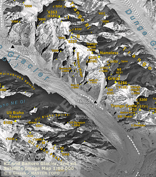
The Trango Towers are a group of dramatic granite spires located on the north side of the Baltoro Glacier between Uli Biaho in the West and Muztagh Towers in the east. The Towers offer some of the largest cliffs and most challenging rock climbing in the world. In fact, the east face of the Great Trango Tower is commonly considered the tallest vertical face in the world.
All of the Trango Towers lie on a ridge, trending northwest-southeast, between the Trango Glacier on the west and the Dunge Glacier on the east. The group is reasonable easy to access as it is located much closer to civilization than many other popular peaks in Pakistan.
The highest point in the group is the large massif of Great Trango Tower culminating at 6286m high main summit. Just northwest of Great Trango is the Trango Tower (6239 m), often called "Nameless Tower". This is a very large, pointed, rather symmetrical spire which juts 1000m out of the ridgeline. North of Trango Tower is a smaller rock spire known as "Trango Monk." To the north of this feature, the ridge becomes less rocky and loses the large granite walls that distinguish the Trango Towers group and make them so attractive to climbers; however the summits do get higher. These summits are not usually considered part of the Trango Towers group, though they share the Trango name. Trango II (6327m) lies northwest of the Monk, and the highest summit on the ridge, Trango Ri (6363m), lies northwest of Trango II. Just southeast of Great Trango (really a part of its southeast ridge) is the Trango Pulpit (6050m), whose walls present similar climbing challenges to those of Great Trango itself. Further to the south is Trango Castle (5753m), the last large peak along the ridge before the Baltoro Glacier.
- American Alpine Journal, year: 2006, isbn: 9781933056012.
- Mountain Info, #512 issue: 30, date: 2007-08. By Lindsay Griffin.
- Mountain Info, #513 issue: 31, date: 2007-09. By Lindsay Griffin.
- Mountain Info, #621 issue: 86, date: 2012-04. By Lindsay Griffin.
- Trango group. At Mastertopo.
- Trango Towers. At SummitPost.
- Slovenian Bonanza in the Trango Group. Alpinist Issue 11 featured a 20-page Mountain Profile on Pakistan's Trango Tower by Trango veteran Greg Child. One year later, the article appears to have inspired a spate of activity, when, in late August, a large group of Slovenians blasted the Trango Group. By Lindsay Griffin at Alpinist on 2006-09-28.
- Trango Group. Trango Group, Various Activity. Since many climbers had told us late summer in the Karakoram has the best rock-climbing weather, we chose that time to visit the Trango towers. By Andrej Grmovsek at Alpinist on 2007-03-01.
- Mexican climber, Pakistani cook go big. From July 19-22 a Mexican climber, Luis Carlos Garcia Ayala, and Pakistani cook and guide, Ali Muhammad, opened a route on La Reina Roja (aka The Red Queen), the southwest-facing wall above Sadu Peak (4400m), in the Trango Range, Pakistan Karakoram. By Chris Zajchowski at Alpinist on 2007-08-22.
- Trango Towers Group. From August 2-September 28, Klemen Mali, Miha Valic and I climbed in the Trango group. Our main target was the southwest ridge of Great Trango Tower, but a few days before our departure, we got the news that Josh Wharton and Kelly Cordes had climbed it. We were a little disappointed but not too sad because there are a lot of good mountains in the area. By Tomaz Jakofcic at Alpinist on 2005-03-01.
- Karakoram development continues. The last couple of years have seen the Trango Glacier establish itself as perhaps the world's preeminent alpine-rock playground. Climbing Trango Tower (6239m; see Alpinist 11's Mountain Profile for complete route details) has become a far more accessible goal since the Pakistan government, forced to realize the long-term implications of restrictive regulations, raised the altitude, below which peaks in open areas would be free of royalty and cumbersome liaison officer services, to 6500 meters. By Lindsay Griffin at Alpinist on 2006-10-26.
- New routes and a virgin peak above the Trango Glacier. A Polish Sage Symfonia Polish Karakorum Expedition, Pakistan 2006 operated in the area of Trango Towers in the Karakoram between the end of August and 20th of September. The climbing team included Maciej Ciesielski, Jakub Radziejowski and Wawrzyniec Zakrzewski. By Jakub Radziejowski at ClimbAndMore.com.
Muztagh Tower group
Group located to the East of Trango group and west of Chongtar-Skil Brum and K2. Significantly higher but less known than the climbs of Trango group. Both routes climbed in 1956 were among the most difficult climbing ever done at such altitude at the time.
Lobsang group
Peaks between Trango group and Dunge glacier in the west and Muztagh glacier and Tower in the east.
Choricho group
| 1979-08-01 | Choricho, , First ascent | Ian R. Wade, Michael Goff, Geoffrey Childs, William Miller, Jawed Shaukat |
Payu group
| 1976-07-20 | Paiyu Peak, North side, First ascent | North side: Major Bashir Ahmed, Major Manzoor Hussain, Nazir Ahmed Sabir |
| 2014-07-26 | Paiyu Peak, 2T, First ascent | 2T: Alberto Inurrategi, Juan Vallejo, Mikel Zabala |
- Payu Peak (6610-M), Karakoram, Pakistan. By Afzal at SummitPost on 2009-09-03.
- American Alpine Journal, year: 1977, isbn: 9780930410230, pp: 42.'Payu, Karakoram' by Manzoor Hussain.
- American Alpine Journal, year: 1985, isbn: 9780930410247, pp: 320.'Payu Attempt' by Antoni Bahí.
- American Alpine Journal, year: 2015, isbn: 9781933056876, pp: 320.'Paiju Peak, South Pillar, Via 2T' by Ana Larizgoitia.
- Trio of Basques Dodge (Most) Rock Fall on Payu Peak. On July 26, Alberto Inurrategi, Juan Vallejo and Mikel Zabala made the first recorded ascent of 6600-meter Payu Peak's south pillar. By Shey Kiester at Alpinist on 2014-07-30.
| 1979-07-03 | Uli Biaho Tower, Direct east face, First ascent | Direct east face: John Roskelley, Kim Schmitz, Ron Kauk & Bill Forrest |
| 1988-06-21 | Uli Biaho Tower, South pillar, First ascent | South pillar: Maurizio Giordani, Rosanna Manfrini, Maurizio Venzo & Kurt Walde |
| 2006-06-25 | Uli Biaho Tower, Drastissima, First ascent | Drastissima: Gabo Cmarik & Jozef Kopold |
| 2013-07-21 | Uli Biaho Tower, West face, First ascent | West face: Matteo Della Bordella, Luca Schiera, Silvan Schüpbach |
| 2013-08-14 | Uli Biaho Tower, Russian Roulette, First ascent | Russian Roulette: Denis Veretenin & Evgenii Bashkirtcev |
- : Stories Off the Wall, Reprint edition. Isbn: 9780898866094. Mountaineers Books, 1998.
- Mountain Info, #671 issue: 105, date: 2013-11.
- American Alpine Journal, year: 1980, isbn: 9780930410766, pp: 405–416.'The Obvious Line: Uli Biaho' by Josh Roskelley.
- American Alpine Journal, year: 2010, isbn: 9781933056234.
- Uli Biaho Tower - American Route - 1979. Uli Biaho Tower, in the Karakoram mountains (Pakistan) was climbed for the first time in 1979 by John Roskelley, Ron Kauk, Bill Forrest and Kim Schmitz. By Himalaya Masala at Himalayan Climbs on 2013.
- Uli Biaho Tower - Veretenin-Bashkirtsev Route - 2013. Russian climbers Denis Veretenin and Eugeny Bashkirtsev climbed a new route on the east face of Uli Biaho Tower, in Pakistan's Karakoram mountains, in August 2013. By Himalaya Masala at Himalayan Climbs on 2013.
- Mountain Info, #671 issue: 105, date: 2013-11.
- Uli Biaho Tower - West Face - 2013. Matteo Della Bordella and Luca Schiera from Italy and Silvan Schüpbach from Switzerland have made the first ascent of a new route up the West Face of Uli Biaho Tower (6109m) in Pakistan. By Himalaya Masala at Himalayan Climbs on 2013.
- Europeans Find the Easiest Rock Route Up Uli Biaho. Last month, Italian climbers Matteo Della Bordella and Luca Schiera and Swiss climber Silvan Schupbach made their contribution to what has been a surprisingly productive Karakoram climbing season, after the Nanga Parbat attack in June cast a dire outlook on mountain tourism in Pakistan. On July 21, the trio summited Uli Biaho (6109m), in the Trango Towers region, by a mostly new and free route on the southwest face. By David Crothers at Alpinist on 2013-08-08.
- Uli Biaho new Trango climb by the Ragni di Lecco. Matteo Della Bordella, Luca Schiera and Silvan Schüpbach have safely reached Base Camp after having forged a new route up the West Face of Uli Biaho (6109m), Trango, Pakistan. By PlanetMountain at Planet Mountain on 2013-07-22.
- American Alpine Journal, year: 2007, isbn: 9781933056050, pp: 75.'A Taste of Karakoram Ice, Exploring the Early-Season Potential above the Trango Glacier' by Dodo Kopold.
- Uli Biaho Tower. I don't look for adventure on the classic routes, where you stumble over hundreds of people, nor even on routes that have been climbed several times. I want to start where others have wrecked. By Dodo Kopold at Alpinist on 2006-11-27.
- Uli Biaho new route by Kopold and Cmarik. Dodo Kopold and Gabo Cmarik have made the f.a. of the NW Face of Uli Biaho 6417m, Karakorum, Pakistan. They also climbed a route up Hainabrakk East Tower (5800m) to 5375m. By PlanetMountain at Planet Mountain on 2006-08-03.
- American Alpine Journal, year: 2008, isbn: 9781933056074.
- Mountain Info, #503 issue: 21, date: 2006-11.
- American Alpine Journal, year: 2009, isbn: 9781933056098.
- American Alpine Journal, year: 2008, isbn: 9781933056074.
- Cats Ear Spire sees second ascent. By Micah Dash at Alpinist on 2006-12-11.
| 1997-08-01 | Shipton Spire, Ship of Fools, First ascent | Ship of Fools: Jared Ogden & Mark Synnott |
| 1998-01-01 | Shipton Spire, Inshallah, First ascent | Inshallah: Steph Davis, Kennan Harvey & Seth Shaw |
| 2001-08-01 | Shipton Spire, Women and Chalk, First ascent | Women and Chalk: Mauro Bole, Fabio Dandri & Mario Cortese |
- Mountain Info, #489 issue: 7, date: 2005-09.
- Mountain Info, #503 issue: 21, date: 2006-11.
- American Alpine Journal, year: 2007, isbn: 9781933056050, pp: 75.'A Taste of Karakoram Ice, Exploring the Early-Season Potential above the Trango Glacier' by Dodo Kopold.
- American Alpine Journal, year: 2008, isbn: 9781933056074.
- Shipton Spire 5852m, East Face. At ClimbAndMore.com.
- Great Trango Tower, Hainabrakk East and Shipton Spire. By Vladimir Linek at Alpinist on 2006-03-01.
- Shipton Spire, 5852м. At Mountain.ru.
- Two More routes added to Shipton Spire. The ever-popular Shipton Spire (5885m) in Pakistan's Karakoram gained two new lines this summer: the first by a team of four Russians who took the full height of the southeast face, and the second a spirited solo effort by Spain's foremost female big wall climber, Silvia Vidal. By Lindsay Griffin at Alpinist on 2007-08-16.
- American Alpine Journal, year: 1998, isbn: 9780930410780.
- High #183
- American Alpine Journal, year: 2002, isbn: 9780930410919.
- High #234
- American Alpine Journal, year: 2007, isbn: 9781933056050, pp: 338.'Shipton Spire, Women and Chalk, Second Ascent and First to Summit; Trango Tower, Eternal Flame, not to Summit; Trango II, Second Known Ascent; Little Shipton, First Ascent' by Hansjörg Auer & Thomas Scheiber.
- Women and chalk. By Mauro Bole at Planet Mountain.
- American Alpine Journal, year: 1999, isbn: 9780930410841, pp: 80-89.'Free as Can Be in the Pakistan Karakoram' by Steph Davis.
- American Alpine Journal, year: 2001, isbn: 9780930410896.
- High #234
Trango group
- American Alpine Journal, year: 2013, isbn: 9781933056791.
| 1995-01-01 | Trango II, SE ridge, First ascent | SE ridge: Antonio Aquerreta, Ferman Izco & Mikel Zabalza |
| 2005-01-01 | Trango II, Severence Ridge, First ascent | Severence Ridge: Samuel Johnson, Jonathon Clearwater & Jeremy Frimer |
- Alpinist, issue: 15.'Trango II Severance Ridge' by Jeremy Frimer.
- NZ Alpine Journal 2005
- American Alpine Journal, year: 2006, isbn: 9781933056012, pp: 353.'Trango II Severance Ridge' by Jeremy Frimer.
- American Alpine Journal, year: 2013, isbn: 9781933056791.
- Mountain Info, #503 issue: 21, date: 2006-11.
- International Uli Biaho Expedition 2005. Final report. At International Uli Boaho Expedition 2005.
| 2004-01-01 | Trango Monk, Chota Badla, First ascent | Chota Badla: Miha Valic & Tomaz Jakofcic |
- Mountain Info, #489 issue: 7, date: 2005-09.
- Trango Towers Group. From August 2-September 28, Klemen Mali, Miha Valic and I climbed in the Trango group. Our main target was the southwest ridge of Great Trango Tower, but a few days before our departure, we got the news that Josh Wharton and Kelly Cordes had climbed it. By Tomaz Jakofcic at Alpinist on 2005-03-01.
- Sons of Tomo Cesen Storm Karakoram. After our unsuccessful expedition to the Trangos in 2004, my friend Matevz Kunsic and I wanted to return to the great people and mountains of Baltistan. This time, the brothers Nejc and Ales Cesen joined us; and with another five Slovenian climbers, we set off for the best golden granite I've ever seen. Our goal was an alpine ascent on Trango Tower, and we really wanted to climb it free. By Matjaz Jeran at Alpinist on 2006-12-20.
| 1900-01-01 | Trango Tower, , Event | Wolfgang Gullich, Kurt Albert, Milan Sykora & Christoph Stiegler Alexander Huber & Thomas Huber |
| 1900-01-01 | Trango Tower, , Event | Slavko Čankar, Franček Knez & Bojan Šrot Kurt Albert, Wolfgang Güllich & Hartmut Münchenbach |
| 1976-01-01 | Trango Tower, British Route, First ascent | British Route: Malcolm Howells, Martin Boysen, Joe Brown & Mo Anthoine |
| 1987-01-01 | Trango Tower, Gran Diedre Desplomado, First ascent | Gran Diedre Desplomado: Michel Piola, Stéphane Schaffter, Patrick Delale & Michel Fauquet |
| 1995-01-01 | Trango Tower, Insumisioa, First ascent | Insumisioa: Antonio Aqueretta, Fermin Izco & Mikel Zabalza |
| 2011-08-01 | Trango Tower, No Fear, First ascent | No Fear: Dmitry Golovchenko, Sergey Nilov, Viktor Volodin & Alexander Yurkin |
- : Himalaya Alpine Style - The Most Challenging Routes on the Highest Peaks. Isbn: 9780898864564. Mountaineers Books, 1996.
- : Trango. Isbn: 9780950627205. Dark Peak Limited, 1978.
- : Beyond the Summit - Setting and Surpassing Extraordinary Business Goals. Isbn: 159184004X. Portfolio Hardcover, 2003.
- : Postcards From the Ledge - Collected Mountaineering Writings of Greg Child. Isbn: 9780898867534. The Mountaineers Books, 1998.
- +Belles pp.107
- American Alpine Journal, year: 1988, isbn: 9780930410339.
- Mountain 1988-02
- American Alpine Journal, year: 1988, isbn: 9780930410339.
- http://www.supertopo.com/climbers-forum/553289/Trango-Tower-FA-1976-Classic-Martin-Boysen-MT-52 Last Trango http://www.supertopo.com SuperTopo Our mission at SuperTopo is to create the world's best climbing guidebooks. SuperTopo.com is designed to be a resource to help you plan a climbing itinerary, as well as get the best topos available for those climbs. We currently include detailed info on over 380 of Yosemite's best big wall and free climbs —including photos, stats, links for related sites, and user submitted beta with the latest info. Mountain #52
- American Alpine Journal, year: 1977, isbn: 9780930410230.
- Alpine Journal, year: 1977.'Trango conclusion' by J. V. Anthoine.
- American Alpine Journal, year: 1990, isbn: 9780930410438.
- Climb 2006-11
- American Alpine Journal, year: 2010, isbn: 9781933056234, pp: 270-271.'Trango Tower, Eternal Flame, First Free Ascent' by Thomas Huber.
- Hubers Redpoint Eternal Flame. Over four days in mid-August, German brothers Alexander and Thomas Huber became first to redpoint Eternal Flame (VI 7c+ [5.13a], 650m) on the south face of Trango Tower (6239m) in the Trango Group of Pakistan's Karakoram range. Beyond qualifying for one of the world's hardest free climbs above 20,000 feet, the ascent puts to rest controversy that has surrounded the iconic line for two decades. By Erik Lambert at Alpinist on 2009-10-01.
- Eternal Flame. Eternal Flame is a world-famous multi-pitch route up the Nameless Tower in the famous granite Trango group in Pakistan's Karakorum mountain range. By PlanetMountain at Planet Mountain on 2009-10-01.
- Eternal Flame on Trango Tower. Making the best of a stretch of good weather, between August 11th and 14th 2009, the well known German climbing super-stars Alexander and Thomas Huber successfully completed the first redpoint ascent of Eternal Flame on Nameless Tower (Trango Tower) in the Karakoram. By Alexander Huber & Thomas Huber at UKC Climbing on 2009-09.
- American Alpine Journal, year: 1989, isbn: 9780930410391.
- Sons of Tomo Cesen Storm Karakoram. After our unsuccessful expedition to the Trangos in 2004, my friend Matevz Kunsic and I wanted to return to the great people and mountains of Baltistan. This time, the brothers Nejc and Ales Cesen joined us; and with another five Slovenian climbers, we set off for the best golden granite I've ever seen. Our goal was an alpine ascent on Trango Tower, and we really wanted to climb it free. By Matjaz Jeran at Alpinist on 2006-12-20.
- American Alpine Journal, year: 2012, isbn: 9781933056753.
- Russians Siege Trango, Put Up New Route. Last month, a four-man Russian team established a new route on the northwest face of Pakistan's Trango Tower (6251m). No Fear (VII 6B+ A3, 1120m) put up by Dmitry Golovchenko, Sergey Nilov, Viktor Volodin and Alexander Yurkin, is the first largely independent route established on Trango Tower in more than a decade. By Casey O'Malley at Alpinist on 2011-09-28.
- The First Russian Route on Trango Tower. In august 2011 a new route on Trango Tower (Nameless Tower) wall was put up by the Moscow Mountaineering and Climbing Federation team during the expedition to Karakoram. This is the first Russian route on this mountain. By Alex Yurkin at Mountain.ru.
- Main (6286m35.76666776.183333)
- South (6250m)
- East (6231m)
- West (6223m)
| 1977-07-21 | Great Trango Tower, American route, First ascent | American route: Galen Rowell, John Roskelly, Kim Schmitz & Dennis Hennek |
| 1984-01-01 | Great Trango Tower, Norwegian Buttress, First ascent | Norwegian Buttress: Hans Christian Doseth & Finn Dæhli |
| 1984-08-19 | Great Trango Tower, NW Ridge, First ascent | NW Ridge: Andy Selters & Scott Woolums |
| 1992-01-01 | Great Trango Tower, The Grand Voyage, First ascent | The Grand Voyage: Xaver Bongard & John Middendorf |
| 1999-01-01 | Great Trango Tower, Lost Butterfly, First ascent | Lost Butterfly: Berecz, Nadaski & Tivadar |
| 1999-08-01 | Great Trango Tower, Parallel Worlds, First ascent | Parallel Worlds: Mark Synnott, Alex Lowe, Jared Ogden, Darren Britto, Greg Thomas, Jim Suretto & Mike Graber |
| 1999-08-10 | Great Trango Tower, Russian Direct, First ascent | Russian Direct: Yuri Koshelenko, Alexander Odintsov, Igor Potankin & Ivan Samiolenko |
| 2003-01-01 | Great Trango Tower, The Ukrainian Route, First ascent | The Ukrainian Route: Lavrinenko, Mogila, Yarechevsky & Zhilin |
| 2004-01-01 | Great Trango Tower, Azeem Ridge, First ascent | Azeem Ridge: Josh Wharton & Kelly Cordes |
| 2005-01-01 | Great Trango Tower, Assalam Alaikum, First ascent | Assalam Alaikum: Gabo Cmarik & Jozef Kopold |
| 2011-08-28 | Great Trango Tower, Parallelniy Mir, First ascent | Parallelniy Mir: Marina Kopteva, Galina Chibitok & Anna Yasinskaya |
- Alpinist, issue: 11.
- American Alpine Journal, year: 2013, isbn: 9781933056791.
- +Belles pp.107
- American Alpine Journal, year: 1978, isbn: 9780930410742, pp: 436.'Great Trango Tower' by Dennis Hennek.
- Great Trango - Normal Route - 1977. By Himalaya Masala at Himalayan Climbs on 2012.
- American Alpine Journal, year: 1985, isbn: 9780930410247, pp: 320.'The Obvious Line: Uli Biaho' by Scott Woolums.
- American Alpine Journal, year: 2006, isbn: 9781933056012, pp: 72.'Up and Down Great Trango Tower' by Dodo Kopold.
- Great Trango Tower, Hainabrakk East and Shipton Spire. By Vladimir Linek at Alpinist on 2006-03-01.
- Great Trango new route by Kopold and Cmarik. In mid-August Dodo Kopold and Gabo Cmarik from Slovakia made the first ascent of "Assalam Alaikum" UIAA VIII A2, ABO on Great Trango, Pakistan. By PlanetMountain at Planet Mountain on 2005-09-16.
- Dodo Kopold on Assalam Alaikum, a New Route on Great Trango. At ClimbAndMore.com.
- Mountain Info, #489 issue: 7, date: 2005-09.
- Alpine Journal, year: 2005, pp: 103-110.'Just Climbing' by Kelly Cordes.
- American Alpine Journal, year: 2005, isbn: 9780930410971, pp: 99.'Suffer Well' by Kelly Cordes.
- Great Trango Tower, Northwest Face. By Vladimir Mogila at Alpinist on 2003-12-01.
- Two new routes on Great Trango's Northwest face. A team of young climbers from the Siberian city of Krasnoyarsk, Russia, completed two first ascents on the huge northwest face of Great Trango (6286m), Pakistan Karakoram, one of the biggest rock walls in the world. By Lindsay Griffin at Alpinist on 2007-07-27.
- Polish Team Establishes New Route on Great Trango Tower. Marek Raganowicz and Marcin Tomaszewski of Poland have established a new route on Great Trango Tower, a 6282m (20,610-foot) granite big wall in Pakistan’s Karakorum range. The route rises up the right side of the tower before linking up with the Azeem Ridge and the path to the summit. By Andrew Hewitt at Climbing Magazine on 2013-09-12.
- Out of Reality, Kopold and Sabovcik new route attempt on Great Trango Tower. This August the Slovak climbers Dodo Kopold and Michal Sabovcik forged a new line up the NW Face of Great Trango Tower (6286m), Karakorum. Their "Out of Reality" ends on the shoulder circa 400m below the summit. By PlanetMountain at Planet Mountain on 2012-09-14.
- Great Trango Tower: Raganowicz and Tomaszewski climb Bushido. Interview with Polish alpinist Marek Raganowicz who talks about the new big wall Bushido (VII A4 VII+), established together with Marcin Tomaszewski up Great Trango Tower, Karakorum, Pakistan. By PlanetMountain at Planet Mountain on 2013-09-20.
- American Alpine Journal, year: 2008, isbn: 9781933056074.
- Mountain Info, #621 issue: 86, date: 2012-04. By Lindsay Griffin.
- American Alpine Journal, year: 2012, isbn: 9781933056753. By Lindsay Griffin.
- Russian/Ukrainian Women Climb New Route on Great Trango. Parallelniy Mir (VI+ 6b A3). By Casey O'Malley at Alpinist on 2011-12-24.
- Mountain Info, #621 issue: 86, date: 2012-04. By Lindsay Griffin.
- American Alpine Journal, year: 2000, isbn: 9780930410872, pp: 100-107.'Great Trango Tower's Northwest face' by Jared Ogden.
- Mountain Info, #621 issue: 86, date: 2012-04. By Lindsay Griffin.
- American Alpine Journal, year: 2000, isbn: 9780930410872, pp: 108-114.'The Russian Way' by Yuri Koshelenko.
- Mountain Info, #621 issue: 86, date: 2012-04. By Lindsay Griffin.
- American Alpine Journal, year: 1985, isbn: 9780930410247, pp: 318.'Ascent of Southeast Face and Tragedy'
- American Alpine Journal, year: 1992, isbn: 9780930410513, pp: 247.'Great Trango Tower, Northeast Buttress'
- American Alpine Journal, year: 2009, isbn: 9781933056098, pp: 278-279.'Great Tango Tower, Norwegian Pillar' by Stein-Ivar Gravdal.
- Norwegians Repeat Historic Trango Route. A four-man Norwegian team has made the probable second complete ascent of the Norwegian Buttress (VII 5.10+ A4) on Great Trango Tower in Pakistan. Rolf Bae, Bjarte Bø, Sigurd Felde, and Stein Ivar Gravdal climbed the 4,500-foot northeast pillar of Great Trango and then continued to the 20,443-foot eastern summit. The ascent required 27 days, followed by three days to descend. By Dougald MacDonald at Climbing Magazine.
- Great Trango Testpiece Finally Climbed Again. By Will Pass at Alpinist on 2008-06-20.
- American Alpine Journal, year: 1995, isbn: 9780930410612, pp: 99.'Great Trango Tower' by Xaver Bongard.
- The Grand Voyage. By John Middendorf at Big Wall Climbing Home Page.
| 1999-01-01 | Trango Pulpit, Norwegian route, First ascent | Norwegian route: Robert Caspersen, Gunnar Karlsen, Per L. Skjerven & Einar Wold |
| 1999-01-01 | Trango Pulpit, More Czech Less Slovak, First ascent | More Czech Less Slovak: vo Wondracek, Tomas Rinn, Pavel Weisser, Jaro Dutka & Michal Drasar |
- American Alpine Journal, year: 2000, isbn: 9780930410872, pp: 91-99.'The Trango Pulpit - a journey under the skin' by Robert Caspersen.
- Mountain Info, #503 issue: 21, date: 2006-11.
- Mountain Info, #503 issue: 21, date: 2006-11.
Muztagh Tower group
- Muztagh Tower East (7284m35.82833333376.360833333)
- Muztagh Tower West (7280m)
| 1956-01-01 | Muztagh Tower, SE ridge, First ascent | SE ridge: Guido Magnone, Robert Paragot, Andre Contamine & Paul Keller |
| 1956-01-01 | Muztagh Tower, NW Ridge, First ascent | NW Ridge: John Hartog, Ian McNaught-Davis, Joe Brown & Tom Patey |
| 1956-07-01 | Muztagh Tower, , First ascent | Guido Magnone, Robert Paragot, Andre Contamine & Paul Keller |
| 2008-08-24 | Muztagh Tower, NE Wall, First ascent | NE Wall: Pavle Kozjek & Dejan Miškovič |
| 2012-08-25 | Muztagh Tower, Russian route, First ascent | Russian route: Sergei Nilov, Dmitry Golovchenko & Alexander Lange |
- Mountain Info, #504 issue: 22, date: 2006-12.
- American Alpine Journal, year: 2012, isbn: 9781933056753, pp: 295-297.'Muztagh Tower (7,284m), northeast spur, Think Twice.' by Dmitry Golovchenko.
- Russians Climb New Route on Muztagh Tower. Amidst a flurry of bad weather, Russians Sergey Nilov, Dmitry Golovchenko, and Alexander Lange have successfully established a new route up the North-East Buttress of Muztagh Tower in Pakistan's Karakoram Range. By Taylor VanRoekel at Alpinist on 2012-10-01.
- Russians climb coveted northeast face of Muztagh Tower. Three Russians, climbing in good style, have made the first ascent of the impressive northeast face of Muztagh Tower (7,284m) in Pakistan's Baltoro Muztagh. By Lindsay Griffin at The British Mountaineering Council on 2012-09-29.
- American Alpine Journal, year: 2009, isbn: 9781933056098, pp: 279-281.'Muztagh Tower, Northeast Face' by Dejan Miskovic.
- Alpine Journal, year: 1986, isbn: 9780900523519, pp: 74-76.'The Second Ascent of the Mustagh Tower' by Mal Duff.
- Alpine Journal, year: 1992, pp: 239-245.'Karakoram 1990' by Paul Nunn.
| 1977-07-22 | Biale Kangri, , First ascent | Party from Jp |
- American Alpine Journal, year: 1989, isbn: 9780930410391.
- : Thin Air, 2 Reprint Edition edition. Isbn: 9780898865882. The Mountaineers Books, 1988.
- American Alpine Journal, year: 1997, isbn: 9780930410711.
- American Alpine Journal, year: 1984, isbn: 9780930410230, pp: 28.'Lobsang Spire' by Doug Scott.
Northern Baltoro Muztagh
Northernmost part of Baltoro Muztagh located between Trango group in the west and Gasherbrum group in the east. The group contains several high peaks, yet it is completely dominated by K2, which is the only peak in the area that gets regularly climbed. The peaks are almost always climbed from Godwin-Austen glacier or one of its tribunaries. The areas located on the north side of Baltoro Muztagh main chain are very remote and get visited very seldom. The access is trough China and involves major logistical challenges. Only North side of K2 gets occasionally climbed.
- : K2 and Northern Baltoro Mustagh. Isbn: 8386054956. Explo Publishers, 1998.
Chongtar group
Group located between Sarpo Laggo glacier in the west and Qoqori glacier in the east. Chongtar group is north-south chain just north of Skil Brum and west of Savoia Pass (6258m). The highest peak is in the souther part of the group, not far from Savoia pass. All other aspects of the group require approach from the Chinese side; from Sarpo Laggo glacier on the west side and Qoqori glacier on the east side. Not much information about climbing is available.
Skil Brum
North-South chain between Muztagh Tower group in the west and Savoia and Godwin Austen glaciers (K2) in the east. The group has three main ridges: NW ridge connects Skil Brum with Savoia Pass (6258m) and K2, west ridge leads to Moni Pass and Muztagh Tower and south ridge leads to Concordia. Despite the peaks being high, they are overshadowed by neighboring Trango group and Muztagh Tower in the West and K2 in the east.
K2 group
K2 group really consists just of one mountain, although there are few other summits on the ridges. The peaks has classic pyramid shape with six main ridges:
- NE ridge to Skyang La. There are several towers along the ridge: Shanjian 2, Shanjian 1 (7187m) and Xiafong (6845m) names on a Chinese map.
- SE ridge (Abruzzi ridge) with Shoulder Peak (7722m)
- SW ridge (SSW ridge, South ridge) to Negrotto pass and Angelus Peak (6802m)
- West ridge
- NW ridge to Savoia la (6258). 4km with 23000m altitude gain
- North ridge to Qogori glacier. The ridge split the north side into narrow NW face and wide N(E) faces.
Skyang Kangri group
Skyang Kangri has three main peaks located on the Baltoro main ridge. There are additionally three separate ridge systems generally towards north. Alöö three groups have peaks above 600 and generally next to nothing is known about the climbing. Most of the peaks, including the highest, don't even have names.
Baltoro main chain extends from Skyang SW La over Skyang Kangri III, II and I to Skyang La (Windy Gap, 5925m). Skyang Kangri I and II are connected by high ridge with no distinct col. III on the other hand is significantly more independent being separated from II by7038m col.
West Skyang Peaks is the smallest of three ridge systems. It branches off the main chain a south of Skyang Kangri III. The highest peaks of the group is P.6639 which is also one of the very few peaks on all of Skyang Kangru group that has been climbed.
North Skyang Kangri peaks are located on a ridge running north from Skyang Kangri I. Several peaks rise to above 6000m.
East ridge of Skyang Kangri I connects with another north south ridge with several side ridges. The group is known as East Skyang peaks. The group is significantly larges and more complex than the other two Skyand side ridges. The peaks are of similar height than the others, with P.6436 being the highest. The area is the least explored of the little explored groups. No ascents or attempts are known.
- American Alpine Journal, year: 1999, isbn: 9780930410841.'Aghil Mountains, Various Ascents' by John Nankervis.
Skilbrum group
| 1957-06-19 | Skilbrum, , First ascent | Marcus Schmuck & Fritz Wintersteller |
| 1957-06-19 | Skilbrum, East side, First ascent | East side: Marcus Schmuck & Fritz Wintersteller |
- Expedition 1957. By Richard Sale at Broad Peak 8047.
| 2017-07-14 | Praqpa Ri South, SE ridge, First ascent | SE ridge: Andres Bosch, Alejandro Mora |
- Chilean climbers reach two Karakoram summits near Broad Peak. Three Chilean climbers—Andres Bosch, 29, Armando Montero, 36, and Alejandro "Jimmy" Mora, 39—set out for the Karakoram Range in mid-June to explore some unclimbed peaks directly across the Godwin-Austen Glacier from Broad Peak. By Derek Franz at Alpinist on 2017-08-15.
K2 group
K2, the second highest mountain in the world (and possibly the most difficult one of the 8000m peaks), is located in Karakoram range and it rises above Godwi-Austen Glacier. It rises 549 meters higher than the peaks surrounding it. This exposure together with its northernly location (35° northern latitude) subjects the mountain to exceptionally harsh weather.
The easiest routes are on SE (Abruzzi) ridge, which is also by far the most popular side of the peak. West side climbs are reached from Savoia glacier (mostly same approach as to Dogwin-Austen glacier below east side). North side climbs are approached from Chinese Shaksgam valley and sees very few visitors.
Because of its majestic shape and fearsome reputation, K2 is features in climbing related movies "K2" and "Vertical Limit". The latter was filmed in New Zealand's Southern Alps (Camera flies by the NZ Classic SE Ridge of Mt.Aspiring during the end credits).
| 1856-01-01 | K2, , Event | K2 was found by Europeans as late as 1856 as Captain T.G. Montgomerie surveyed it from a distance of roughly 200 kilometers. He gave the mountain a provisory name of K2, where letter K indicates Karakoram and number 2 is reference number. The mountain is also known as Chogori (or Qogir) and Mount Godwin-Austen (after Henry Haversham Godwin-Austen, first Surveyor-General of the Survey of India). |
| 1902-01-01 | K2, , Event | First attemp was made in 1902 by a party lead by Oscar Eckenstein. They reached altitude of 6524 meters on NE-ridge. The most feasible route was found 1909 by the Duke of the Abruzzi's expedition on SE-ridge, which is now known as Abruzzi Ridge. In 1953 a seven man team led by Charles S. Houston reached 7500 m, but was forced to turn back due bad weather and Thrombosis of Art Gilkey. While lowering Gilkey, the multiple fall dragged five members of the team toward a precipice, but Pete Schoening managed to stop the fall by ice axe belay. Gilkey however went missing during the fall. |
| 1954-07-31 | K2, Abruzzi Ridge, First ascent | Abruzzi Ridge: Achille Compagnoni and Lino Lacedelli. They were members of large Italian expedition led by Ardito Desio. Nine camps were established during the ascent. |
| 1978-01-01 | K2, Without bottled oxygen, First ascent | Without bottled oxygen: Firts ascent without bottled oxygen took place in 1978 by Americans John Roskelley and Rick Ridgeway. They summited together with fellow Americans Jim Wickwire and Louis Reichardt via NE Ridge. |
| 1978-01-01 | K2, NE ridge, First ascent | NE ridge: Louis Reichardt, Jim Wickwire, John Roskelley & Rick Ridgeway |
| 1981-08-07 | K2, West Ridge, First ascent | West Ridge: Eiho Ohtami & Sabir Nazir |
| 1982-08-14 | K2, North Ridge, First ascent | North Ridge: Nakoe Sakashita, Hiroshi Yoshino & Yukihiro Yanagisawa |
| 1986-01-01 | K2, , First free ascent | First female ascents were made in 1986 by Wanda Rutkiewicz (Poland), Lilianne Barrard (France) and Julie Tullis (UK) via Abruzzi Ridge. Tullish perished in storm while still high on the mountain. |
| 1986-01-01 | K2, , Ascent | Benoit Chamoux (France) ascended Abruzzi Ridge in 1986 from ABC to summit in just 22,5 hours only few days after soloing Broad Peak in 16 hours. |
| 1986-01-01 | K2, South Face, First ascent | South Face: Jerzy Kukuczka & Tadeusz Piotrowski |
| 1986-08-03 | K2, Magic Line, First ascent | Magic Line: Peter Bozek, Przemyslaw Piasecki & Wojiech Wroz |
| 1990-01-01 | K2, NW face, First ascent | NW face: H. Imamura & H. Nazuka |
| 1991-01-01 | K2, NW Ridge, First ascent | NW Ridge: Christophe Profit & Pierre Béghin |
| 1994-01-01 | K2, SSE Spur, First ascent | SSE Spur: De Pablo, Alberto Iñurrategi, Felix Iñurrategi, Oiarzabal, Tómas |
| 2007-08-21 | K2, Russian Direct, First ascent | Russian Direct: Andrey Mariev & Vadim Popovich |
- Top Climbs pp.40-47
- World Mountaineering pp.216-223
- Alpinist, issue: 37, pp: 38-61.'K2: The Mountaineer's Mountain' by Steve Swenson.
- Alpinist, issue: 38, pp: 36-69.'K2: The Mountaineer's Mountain: Part II (1974-2012)' by Steve Swenson.
- Mountain Info, #484 issue: 2, date: 2005-04. By Lindsay Griffin.
- Mountain Info, #488 issue: 6, date: 2005-08. By Lindsay Griffin.
- Mountain Info, #504 issue: 22, date: 2006-12. By Lindsay Griffin.
- +Belles pp.103
- : K2, the Savage Mountain. Isbn: 1585740136. Lyons Press, 2000.
- : K2 - The Price of Conquest. Isbn: 9781594850301. Mountaineers Books, 2006.
- : Savage Summit - The Life and Death of the First Women of K2. Isbn: 9780060587161. Harper Paperbacks, 2006.
- : K2 - Triumph and Tragedy. Isbn: 9780395485903. Mariner Books, 1989.
- : Mixed Emotions. Isbn: 9780898863635. The Mountaineers, 1993.
- : Buried in the Sky - The Extraordinary Story of the Sherpa Climbers on K2's Deadliest Day, 1 Edition edition. Isbn: 9780393345414. W. W. Norton & Company, 2013.
- : The Endless Knot - K2, Mountain of Dreams and Destiny. Isbn: 9780898863000. Mountaineers Books, 1991.
- : K2 - Traum Und Schicksal. Isbn: 9783492405294. Piper Verlag Gmbh, 2013.
- : K2 - Challenging the Sky. Isbn: 9780831710729. Smithmark Pub, 1995.
- : Clouds From Both Sides. Isbn: 9780586067659. Grafton Books, 1987.
- : The Time Has Come - Ger Mcdonnell - His Life & His Death on K2. Isbn: 9781848891432. Collins Pr, 2012.
- : No Way Down - Life and Death on K2. Isbn: 9780061834790. Harpercollins, 2011.
- : K2 - Life and Death on the World's Most Dangerous Mountain, 1 Reprint Edition edition. Isbn: 9780767932608. Broadway Books, 2010.
- : One Mountain Thousand Summits - The Untold Story of Tragedy and True Heroism on K2, Paperback Edition edition. Isbn: 9780451233318. New American Library, 2011.
- : K2 Surviving Three Days in the Death Zone, 1th Edition Edition edition. Isbn: 9789089270467. G+J Publishing CV, 2010.
- : The Summit - How Triumph Turned to Tragedy on K2's Deadliest Days. Isbn: 9781847176431. O'brien Press Ltd, 2013.
- K2 - the mountaineer's mountain. Topo of the Pakistani site (West and South sides). At http://www.photographic.co.nz.
- K2 topo. Topo of the Pakistani site (West and South sides). By k2rulez at Photobucket.
- K2: Geschichte + Literatur. By Günter Seyfferth at Die Berge des Himalaya.
- K2 History. By Per Jerberyd at Sweclimber on 1997.
- K2 Climb. By Chip Brown at National Geographic on 2012-04.
- American Alpine Journal, year: 2008, isbn: 9781933056074.
- North ridge. At Mad Ascent.
- Kielkowski #4
- Kielkowski #5
- American Alpine Journal, year: 1991, isbn: 9780930410469, pp: 19.'K2—The North Ridge' by Steve Swenson.
- History of successful K2 North Ridge attempts. The north ridge of K2 is seldom climbed because of the difficulty of getting there. It is on the Chinese side of K2 in contrast to the more popular routes being on the Pakistan side. The Abruzzi Ridge is the most popular way for those who make the summit of K2. By K2 Blog on 2011-08-23.
- Kielkowski #7
- Alpine Journal, year: 1979.'1978 American K2 expedition' by Adam Carter.
- Himalayan Journal, year: 1980.'K2: The American Ascent' by Jim Wickwire.
- : The Last Step - The American Ascent of K2. Isbn: 9780898866322. Mountaineers Books, 1999.
- : A Life on the Edge - Memoirs of Everest and Beyond. Isbn: 9780898867541. Mountaineers Books, 2000.
- : Addicted to Danger - Affirming Life in the Face of Death. Isbn: 9780671019914. Atria Books, 1999.
- : Stories Off the Wall, Reprint edition. Isbn: 9780898866094. Mountaineers Books, 1998.
- Kielkowski #14
- American Alpine Journal, year: 1987, isbn: 9780930410292, pp: 10.'K2's Magic Line' by Janusz Majer.
- American Alpine Journal, year: 2005, isbn: 9780930410971, pp: 353.'K2, Magic Line, Second Ascent, Death' by ExplorersWeb.com.
- K2: first repeat of "Magic line" dedicated to Manel De La Matta. he Catalan expedition and the first repeat of the magic line on K2, Himalaya. By PlanetMountain at Planet Mountain on 2004-09-09.
- Kielkowski #13
- Kielkowski #10
- Kielkowski #9
- K2, 8611 m Südostsporn (Abruzzi-Sporn). Excraction in German from "Himalaya - Magic Lines" by Andy Fanshawe and Stephen Venables.
- Kielkowski #3
- American Alpine Journal, year: 2008, isbn: 9781933056074.
- Russians successfully siege K2's hardest line. Applying the same tactics that they used so successfully on the North Face of Jannu in 2004 and the North Face Direct of Everest the same year, the Russians have done it again on the world's second highest mountain. After a prolonged siege of two and a half months, an extremely strong team led by the legendary Pavel Shabalin made the first ascent of the west face direct on K2, completing what is almost certainly the hardest route on this 8611-meter Karakoram mountain. By Lindsay Griffin at Alpinist on 2007-09-05.
- Kielkowski #15
| 1983-08-09 | Angelus, , First ascent | Party from F/CH |
Chongtar group
| 1994-09-08 | Chongtar Kangri I, , First ascent | Party from Aus/NZ |
Skyang Kangri group
- Skyang Kangri I (Skyang Kangri East, Skyang Kangri Main) (7544m35.92666666776.5675)
- Skyang Kangri II (Skyang Kangri West, Skyang Kangri SW) (7512m)
- Skyang Kangri III (Skyang Kangri NW) (7174m)
| 1976-01-01 | Skyang Kangri, SE ridge, First ascent | SE ridge: Y Fujihji & H. Nagata |
| 1976-08-11 | Skyang Kangri, , First ascent | Y. Fujihji & H. Nagata |
| 1980-01-01 | Skyang Kangri, , Event | Jeff Lowe & Michael Kennedy attempted West face unsuccessfully |
- American Alpine Journal, year: 1981, isbn: 9780930410773, pp: 289.'Skyang Kangri Attempt' by Michael Kennedy.
- American Alpine Journal, year: 2009, isbn: 9781933056098, pp: 281-282.'Skyang Kangri, West Face Attempt' by Nikolay Zakharov.
- Skyang Kangri. To Be Continued…. By Anna Piunova at Mountain.ru.
Eastern Baltoro Muztagh
Broad Peak Group
Broad Peak is not so much a group, rather than a massive single mountain with few side summits. The peaks sits on Baltoro main chain and consists just two main ridges: NE ridge over North peak to Sella Pass and S(W) ridge towards Gaherbrum IV (becomes NW ridge of GIV). Furthermore there's a short side ridge running north-south to the west of Broad Peak between it and Godwin-Austen glacier.
Gasherbrum Group
Gasherbrum is a remote group of peaks located at the northeastern end of the Baltoro Glacier in the Karakoram range of the Himalaya on the border of the Chinese Shaksgam Valley and the Gilgit-Baltistan territory of Pakistan. The massif contains two or three of the world's 8000m peaks depending on whether Broad Peak is considered part of Northern Baltoro Muztagh or Gasherbrum group. Despite the presence of lot-hyper 8000m peaks in the group, the most striking and also alpinistically most important peak is Gasherbrum IV that misses the magic mark by some meters.
Severeal ascents that have pushed the boundaries of what is possible in alpine style have occurred on Broad Peak and Gasherbroum group. Of particular importance are 1957 the first ascent of Broad Peak, 1975 three-day climb in pure alpine style by Reinhold Messner and Peter Habeler, 1984 enchainment of Gasherbrum I and II by Reinhold Messner and Hans Kammerlander and 1985 first ascent of the west face of Gasherbrum IV by Robert Schauer and Wojciech Kurtyka (not to summit).
Sia group
Separated from Gasherbrum group by col SE of Urdok II. East ridge leads first to Indira col and further to Turkestan col, which separates it from Siachen Muztagh. South ridge leads to Sia La, which separates the group from Saltoro Mountains.
Broad Peak Group
| 1983-06-28 | Broad Peak North, North buttress, First ascent | North buttress: Renato Casarotto |
- Eastern Baltoro Muztagh #16
- Central Peak (8016m)
- Main Peak (8047m35.81083333376.568333333)
- SW Peak (7721m)
- North Peak (7550m)
| 1957-01-01 | Broad Peak, West Spur, First ascent | West Spur: Kurt Diemberger, Hermann Buhl, Markus Schmock & Fritz Wintersteller |
| 1957-06-09 | Broad Peak, , First ascent | Kurt Diemberger, Hermann Buhl, Markus Schmock & Fritz Wintersteller in 1957 via West Spur. Neither supplemental oxygen nor high-altitude porters were used. |
| 1983-01-01 | Broad Peak, , First free ascent | Krystyna Palmowska |
| 1984-01-01 | Broad Peak, , Ascent | Kryztof Wielicki (Poland) summited in 16 hours from base camp in 1984 and Benoit Chamoux likewise in 16 hours in 1986. |
| 1984-07-16 | Broad Peak, NW Ridge Integral, First ascent | NW Ridge Integral: Wojciech Kurtyka & Jerzy Kukuczka alpine style |
| 2005-01-01 | Broad Peak, SW face, First ascent | SW face: Samoilov & Denis Urubko |
- Mountain Info, #504 issue: 22, date: 2006-12.
- Mountain Info, #539 issue: 57, date: 2009-11.
- Mountain Info, #649 issue: 93, date: 2012-11.
- Mountain Info, #660 issue: 102, date: 2013-08.
- American Alpine Journal, year: 2009, isbn: 9781933056098, pp: 64-71.'Karakoram Doubleheader' by Valery Babanov.
- Expedition 1957. The First ascent of Broad Peak 8.047m in 1957 by the Austrian OEAV Karakoram Expedition with Hermann Buhl, Kurt Diemberger, Marcus Schmuck and Fritz Wintersteller is a landmark achievement in the history of mountaineering. This Internet platform provides the facts about the expedition and the team members in the interest of the public. Broad Peak Club provides an overview over all later ascents and all climbers reaching the main summit are listed in the database. By Richard Sale at Broad Peak 8047.
- Broad Peak: Geschichte + Literatur. By Günter Seyfferth at Die Berge des Himalaya.
- Success for Inurrategi on Broad Peak. On July 18, Basque climber Alberto Inurrategi completed an alpine-style traverse of Broad Peak (8051m) in Pakistan's Karakoram region. Ten days before, on an earlier attempt of the traverse, Inurrategi, Juan Vallejo and Mikel Zabalza established a new route on the north summit. By Gwen Cameron at Alpinist on 2010-09-24.
- American Alpine Journal, year: 2011, isbn: 9781933056715.
- Eastern Baltoro Muztagh #15, #14, #12, #2, #3
- Eastern Baltoro Muztagh #3
Gasherbrum Group
- Gasherbrum IV (7925m35.762576.616666667)
- Gasherbrum IV North (7900m)
| 1958-08-06 | Gasherbrum IV, , First ascent | Walter Bonatti & Carlo Mauri. They were members of Italian expedition led by Riccardo Cassin. |
| 1958-08-06 | Gasherbrum IV, NE Ridge, First ascent | NE Ridge: Walter Bonatti & Carlo Mauri. They were members of Italian expedition led by Riccardo Cassin. |
| 1985-07-20 | Gasherbrum IV, West Face, First ascent | West Face: Wojciech Kurtyka & Robert Schauer. Bad weather and extreme exhaustion forced them to stop at the north summit, missing the true summit |
| 1986-06-22 | Gasherbrum IV, NW Ridge, First ascent | NW Ridge: Greg Child, Tim Macartney-Snape & Tom Hargis |
| 1997-07-18 | Gasherbrum IV, Central Spur, First ascent | Central Spur: Bang Jung-ho, Kim Tong-kwan & Yoo Huk-jae |
- : Karakoram. Isbn: 9780670411641. Penguin Group (USA) Incorporated, 1961.
- : Himalaya Alpine Style - The Most Challenging Routes on the Highest Peaks. Isbn: 9780898864564. Mountaineers Books, 1996.
- : Thin Air, 2 Reprint Edition edition. Isbn: 9780898865882. The Mountaineers Books, 1988.
- World Mountaineering pp.226-229
- Alpinist, issue: 2.'Mountain Profile: Gasherbrum IV' by Michael Kennedy.
- American Alpine Journal, year: 2010, isbn: 9781933056234.
- +Belles pp.112
- Gasherbrum IV, 7925 m. Erkundung, Erstbesteigung, Erstbegehungen, Ereignisse. By Günter Seyfferth at Die Berge des Himalaya.
- Gasherbrum IV 17th Highest Peak Gilgit–Baltistan. Gasherbrum IV is the 17th highest mountain on Earth and the 6th highest in Pakistan. It is one of the peaks in the Gasherbrum massif. If there's a mountain harder to climb than K2, it's considered to be Gasherbrum IV. Its sheer rock faces are relentless and the objective dangers are many. On top of that, it's located in a part of the world where the weather is very unstable. At whitengreen.com.
- East Baltoro Muztagh #23
- MI 2007-10
- American Alpine Journal, year: 2008, isbn: 9781933056074.
- American Alpine Journal, year: 1987, isbn: 9780930410292.
- East Baltoro Muztagh #22
- Gasherbrums Update. Briefly reported in the August 22, 2008 NewsWire, a super-strong team comprising Alberto Inurrategi, Ferran Latorre, Jose Carlos Tamayo, Juan Vallejo and Mikel Zabalza, regular players in Al Filo de lo Imposible, a Spanish TV documentary series that has now been running for twenty-five years, made the third ascent of the northwest ridge of Gasherbrum IV (7925m). By Lindsay Griffin at Alpinist on 2008-08-30.
- East Baltoro Muztagh #28
- American Alpine Journal, year: 1986, isbn: 9780930410278. By Wojciech Kurtyka.
- World Mountaineering pp.226-229
- East Baltoro Muztagh #27
- Gasherbrum V (7133m35.72916666776.613333333)
- Gasherbrum V East I (7120m)
- Gasherbrum V East II (7050m)
- Gasherbrum V East (Gasherbrum V East III) (7006m)
| 1978-08-01 | Gasherbrum V, East rib, First ascent | East rib: K. Mukaide, M. Sakaguchi & T. Sato to East III |
| 2014-07-25 | Gasherbrum V, Nak-jong Seong & Chi-young Ahn, First ascent | Nak-jong Seong & Chi-young Ahn: Nak-jong Seong & Chi-young Ahn |
- American Alpine Journal, year: 2011, isbn: 9781933056715.
- American Alpine Journal, year: 2013, isbn: 9781933056791.
- East Baltoro Muztagh #32
- Gasherbrum V Alpine-Style First Ascent Realized. On July 25, after climbing in alpine style for three days, Koreans Nak-jong Seong and Chi-young Ahn became the first to stand atop Gasherbrum V, the third highest peak in the Gasherbrum massif at 7147 meters. Their historic feat ticks off one of the last remaining unclimbed peaks in the remote Gasherbrum range in excellent style. By Joe Robinson at Alpinist on 2014-09-22.
- East Baltoro Muztagh pp.87-90
- American Alpine Journal, #AAJ 2017 'Gasherbrum VI, Southwest Ridge, Attempt; Praqpa Ri, East-Southeast Ridge, Attempt' by Nancy Hansen.
| 1987-08-11 | Gasherbrum III, Polish route, First ascent | Polish route: Alison Chadwick, Janusz Onyskiewicz, Wanda Rutkeiwicz & Krzysztof Zdizitowiecki |
- Gasherbrum III, 7952 m. Erkundung, Erstbesteigung, Erstbegehungen, Ereignisse. By Günter Seyfferth at Die Berge des Himalaya.
- Mountain Info, #488 issue: 6, date: 2005-08.
- Eastern Baltoro Muztagh #39
- Himalayan Journal, year: 1976.'Polish ascents of Gasherbrum II and III, 1975' by Janusz Onyskiewicz.
- Gasherbrum II (8035m35.757576.654166667)
- Gasherbrum II East (7772m)
| 1956-07-07 | Gasherbrum II, Austrian route, First ascent | Austrian route: Sepp Larch, Fritz Moravec & Hans Willenpart |
| 1983-06-26 | Gasherbrum II, East ridge, First ascent | East ridge: Jerzy Kukuczka & Wojciech Kurtyka |
- Mountain Info, #488 issue: 6, date: 2005-08.
- Mountain Info, #504 issue: 22, date: 2006-12.
- Mountain Info, #518 issue: 36, date: 2008-02.
- Mountain Info, #539 issue: 57, date: 2009-11.
- American Alpine Journal, year: 1984, isbn: 9780930410230, pp: 37-42.'Gasherbrum II and Hidden Peak - New Routes' by Wojciech Kurtyka.
- Himalayan Journal, year: 1976.'Polish ascents of Gasherbrum II and III, 1975' by Janusz Onyskiewicz.
- Gasherbrum II: Geschichte + Literatur. By Günter Seyfferth at Die Berge des Himalaya.
- Photo Gallery
- Gasherbrum II: A Journey to 26,360 Feet in the Karakoram. By Bob Ader.
- Chinese face of Gasherbrum II east climbed. One of the finest achievements in the Karakoram this season was the first ascent of the Chinese face of 7772-meter Gasherbrum II East by a primarily German-Swiss expedition. By Lindsay Griffin at Alpinist on 2006-09-22.
- Eastern Baltoro Muztagh #45
- American Alpine Journal, year: 1984, isbn: 9780930410230, pp: 37-42.'Gasherbrum II and Hidden Peak - New Routes' by Wojciech Kurtyka.
- American Alpine Journal, year: 2011, isbn: 9781933056715.
- Eastern Baltoro Muztagh #50
| 1983-06-24 | Gasherbrum II East, , First ascent | Jerzy Kukuczka & Wojciech Kurtyka |
- Gasherbrum I (Hidden Peak) (8068m35.72416666776.696666667)
- Hidden Sud (Gasherbrum South) (7069m)
| 1958-07-05 | Gasherbrum I, American route, First ascent | American route: Pete Schoening & Andy Kauffman |
| 1977-06-08 | Gasherbrum I, West ridge, First ascent | West ridge: Stremfelj, Zaplotnik |
| 1983-01-01 | Gasherbrum I, SW face, First ascent | SW face: Jerzy Kukuczka, Wojciech Kurtyka |
| 1986-08-02 | Gasherbrum I, Japanese Couloir, First ascent | Japanese Couloir: O. Shimizu & K. Wakutsu |
| 2008-01-01 | Gasherbrum I, Russian route, First ascent | Russian route: Viktor Afanasiev, Valery Babanov |
| 2017-08-01 | Gasherbrum I, Satisfaction, First ascent | Satisfaction: Marek Holecek, Zdenek Hak |
- Mountain Info, #504 issue: 22, date: 2006-12.
- Mountain Info, #539 issue: 57, date: 2009-11.
- http://www.supertopo.com/climbing/thread.php?topic_id=1867214&msg=1867214#msg1867214 America's Giant- Hidden Peak (Gasherbrum I) Bob Swift 1958 http://www.supertopo.com SuperTopo Our mission at SuperTopo is to create the world's best climbing guidebooks. SuperTopo.com is designed to be a resource to help you plan a climbing itinerary, as well as get the best topos available for those climbs. We currently include detailed info on over 380 of Yosemite's best big wall and free climbs —including photos, stats, links for related sites, and user submitted beta with the latest info. Mountain World 1960/61
- American Alpine Journal, year: 1984, isbn: 9780930410230, pp: 37-42.'Gasherbrum II and Hidden Peak - New Routes' by Wojciech Kurtyka.
- American Alpine Journal, year: 2009, isbn: 9781933056098, pp: 64-71.'Karakoram Doubleheader' by Valery Babanov.
- American Alpine Journal, year: 2011, isbn: 9781933056715.
- American Alpine Journal, year: 2012, isbn: 9781933056753.
- Gasherbrum I: Geschichte + Literatur. By Günter Seyfferth at Die Berge des Himalaya.
- Eastern Baltoro Muztagh #62
- Eastern Baltoro Muztagh #62
- Czech climbers realize 'Satisfaction' on Gasherbrum's southwest face. Marek Holecek has returned to the southwest face of Gasherbrum I (8080) five times since 2009 in a bid to complete a route up the middle of the face through two rockbands. After enduring multiple epics—including the death of his longtime climbing partner in 2013, and a bad case of frostbite in 2016, in addition to other close calls and harrowing descents—Holecek, 43, finished the climb to the top of the mountain with fellow Czech climber Zdenek Hak, 37, at the end of July. By Derek Franz at Alpinist on 2017-08-18.
- American Alpine Journal, year: 1984, isbn: 9780930410230, pp: 37-42.'Gasherbrum II and Hidden Peak - New Routes' by Wojciech Kurtyka.
- Eastern Baltoro Muztagh #75
| 1975-08-04 | Urdok Kangri I, , First ascent | K. Hub, Robert Schauer, H. Schell, L. Schell & H. Zefferer |
- Eastern Baltoro Muztagh pp.143-146
Sia group
| 1934-08-12 | Sia Kangri I, , First ascent | Hans Ertl & Albert Höcht via SW side |
| 1979-07-08 | Mount Hardinge, , First ascent | K. Matsubayashi & Y. Mitamura |
Rakaposhi-Haramosh
Rakaposhi-Haramosh is located in Gilgit district in the SW corner of Karakoram. The area has huge glaciers and peaks have huge prominence as they rise over relatively low valleys. Hunza valley is the most visited part of this range.
Rakaposhi-Bagrot group
Western end on Rakaposhi-Haramosh chain. Rakaposhi is highly commanding presence rising stupendously above the low valleys of Hunza and Nalgar and easily visible to Karakoram Highway. North face ranks among the highest faces in the world. Diran is the other major peak of the group.
Malubiting group
Central peaks on Rakaposhi-Haramosh chain. Besides several Malubiting summits, the main peak of the group is Laila Peak. Laila peak of Rakaposhi-Haramosh group is not to be mixed with lower but a lot more famous peak located in Garherbrum range. Malubiting group is located very close to Spantik on Spantik-Sosbun chain, separated from it by Polan la (5629m). Malubiting has several summits, the highest one is West summit. Of other Malubiting summits North and South/East summits are fairly independent, Central much less so.
Haramosh group
SE end of Rakaposhi-Haramosh chain. Haramosh peaks are separated by the rest of Rakaposhi-Haramosh chain by Haramosh Pass (5100m), that connects Mani and Chogo Lungma glaciers.
Rakaposhi-Bagrot group
- Rakaposhi (Pk 27, Dumani) (7788m36.142574.490833333)
- Rakaposhi East (7010m)
| 1958-06-25 | Rakaposhi, SW Spur, First ascent | SW Spur: Mike Banks & Tom Patey |
| 1979-01-01 | Rakaposhi, North Spur, First ascent | North Spur: Eiho Ohtani & Matsushi Yamashita. |
| 1979-01-01 | Rakaposhi, NW ridge, First ascent | NW ridge: Polish-Pakistani expedition |
| 1985-01-01 | Rakaposhi, East ridge to Rakaposhi East, First ascent | East ridge to Rakaposhi East: Austrian expedition led by Edi Koblmüller |
- Alpine Journal, year: 1981, pp: 185-188.'Rakaposhi from the north' by Shigeru Kodama.
- Mountain Info, #503 issue: 21, date: 2006-11.
- Batura/Rakaposhi NW Spur. By Alberto Peruffo at Mountain.ru on 2005-08-06.
- Himalayan Journal, year: 1965.'Rakaposhi — The North-West Ridge' by J. P. O'F. Lynam.
- http://www.supertopo.com/climbing/thread.php?topic_id=1867947&msg=1867947#msg1867947 Rakaposhi Tom Patey British-Pakistani Forces Expedition 1958 http://www.supertopo.com SuperTopo Our mission at SuperTopo is to create the world's best climbing guidebooks. SuperTopo.com is designed to be a resource to help you plan a climbing itinerary, as well as get the best topos available for those climbs. We currently include detailed info on over 380 of Yosemite's best big wall and free climbs —including photos, stats, links for related sites, and user submitted beta with the latest info. Mountain World 1960/61
- Himalayan Journal, year: 1958.'Rakaposhi climbed' by Mike Banks.
- American Alpine Journal, year: 2009, isbn: 9781933056098.
| 1968-01-01 | Diran, North face, First ascent | North face: Rainer Goeschl, Rudolph Pischinger & Hanns Schell |
| 1968-08-17 | Diran, , First ascent | Rainer Goeschl, Rudolph Pischinger & Hanns Schell |
Malubiting group
- Juto Sar (6785m)
- Malubiting (Peak 46, Malubiting West, Malubiting I) (7458m36.00333333374.875833333)
- Malubiting Central (Malubiting III) (7291m)
- Malubiting North (Malubiting NW, Malubiting II) (7200m)
- Malubiting East (Malubiting SE) (6970m)
| 1971-08-23 | Malubiting, , First ascent | Party from A |
| 1971-08-23 | Malubiting, NE ridge, First ascent | NE ridge: K. Pirker, H. Schell, H. Schindlbacher & H. Sturm |
- American Alpine Journal, year: 1976, isbn: 9780930410735, pp: 543.'Malubiting Central' by Ichiro Yoshizawa.
- American Alpine Journal, year: 1970, isbn: 9781111820190, pp: 188.'Malubiting North' by Günter Oskar Dyhrenfurth.
- American Alpine Journal, year: 1971, pp: 452.'Attempt on Malubiting' by Peter von Gizycki.
- American Alpine Journal, year: 1972, isbn: 9780930410230, pp: 193.'Malubiting, Karakoram' by Hans Schell.
- American Alpine Journal, year: 1998, isbn: 9780930410780, pp: 316.'Malubiting West, Ascent' by Dieter Funfschilling.
- Himalayan Journal, year: 1969.'Autumn under Malubiting' by Andrzej Kus.
- Himalayan Journal, year: 1974.'The First Ascent of Malubiting, 1971' by Horst Schindlbacher.
| 1975-08-09 | Laila Peak, , First ascent | Party from Jp |
| 1979-08-09 | Laila Peak, SE face, First ascent | SE face: Ryuichi Babaguchi & Kohzo Sakai |
- +Belles, pp99
- American Alpine Journal, year: 1976, isbn: 9780930410735, pp: 543.'Laila' by Ichiro Yoshizawa.
| 1959-08-02 | Malubiting SE, , First ascent | Party from UK/Pak |
| 1969-10-08 | Malubiting North East, , First ascent | Party from Pl |
Haramosh group
- Haramosh (7397m35.8474.8975)
- Haramosh Kutwal Laila
| 1958-08-04 | Haramosh, , First ascent | Heini Roiss, Stephan Pauer & Dr. Franz Mandl |
| 1958-08-04 | Haramosh, East ridge, First ascent | East ridge: Heini Roiss, Stephan Pauer & Dr. Franz Mandl |
| 1978-06-22 | Haramosh, West ridge, First ascent | West ridge: Japanese party |
| 1988-01-01 | Haramosh, SW face, First ascent | SW face: Polish party |
- American Alpine Journal, year: 1958.
- American Alpine Journal, year: 1959.
- Himalayan Journal, year: 1958.'1958 Austrian expedition the ascent of Haramosh' by Heini Roiss.
- American Alpine Journal, year: 1989, isbn: 9780930410391.
- Mani I (6650m)
- Thamani (6685m35.86060574.963566)
- Mani II (6522m)
- Mani III (5450m)
- Mani IV (6500m)
- American Alpine Journal, year: 1958.
- American Alpine Journal, year: 1996, isbn: 9780930410643, pp: 305.'Haramosh II, First Ascent and Tragedy' by Dave Wilkinson.
Spantik-Sosbun
The Spantik-Sosbun group is a subrange of the Karakoram in the Northern Areas of Pakistan. It forms the souther bank of both Hispar and Biafpo glaciers. On the southern side, the natural border is Chogo Lungma glacier system. The most famous and the highest peak is Spantik (7027m). Spantik is probably the easiest 7000m peak in Karakoram and correspondingly popular among the climbers. The other namesake peak is Sosbun Brakk (6413m).
Chogo Lungma group
Westernmost part of Spantik-Sosbun chain. Spantik is located close to Malubiting group of Rakaposhi-Haramosh chain, separated from it by Polan la (5629m). Spantik is reputed the easiest 7000m peak in Karakoram and correspondingly popular. The neighboring peaks on the other are very much overshadowed by Spantik and hand see very few climbers.
Balchhish group
The peaks form the southern bank of Hispar glacier. There are several low 6000ers, particularly in the western part of the chain, but well known climbing objectives.
The most famous peaks of the group is likely Solu Towers, located on the eastern end of the chain, very close to Hispar La and Sosbun Brakk. There are four distinct peaks: Solu Peak (5901m), Solu Tower I (5979m), Unnamed and Solu Hidden Tower (ca 5850m). Solu Tower II (5959m) is not very independent, rather a shoulder on Solu Tower I.
- American Alpine Journal, year: 2009, isbn: 9781933056098.
- American Alpine Journal, year: 2013, isbn: 9781933056791, pp: 286-288.'Baintha Brakk (Ogre, 7,285m), north face reconnaissance; Hispar Muztagh, Muki (6,330m), traverse; Peak 5,966m; Sosbun Group, Solu Hidden Tower (ca 5,850m), northeast and northwest faces.' by Hervé Barmasse.
- Der Solu-Gletscher im Karakorum. By Kai Maluck at Deutscher Alpenverein Sektion Braunschweig e. V. Hochtourengruppe.
Sosbun group
Sosbun group is located in the eastern part of Spantik-Sosbun chain, due south of Biafo glacier. The highest peak of the group is Sosbun Brakk which lies close to Solu Tower and not very far from Hispar La. Other than that the group has several low 6000ers and several 5000ers on the chain running south from Spantik_Sosbun chain, particularly Socun Tower and 9 Sosbun Spires. Most of the peaks are accessible either from Sokha glacier is NW or Sosbun glacier in SE. The former glacier is accessible a bit before reaching Arandu at the head of Chogo Lungma glacier or from Hispar glacier via Sokha La. The latter is accessible from the road to Askole or from Hispar glacier via Sokha La and Sosbun-Sokha La (5200m).
South-easternmost part of Spantik-Sosbum chain consists of Ganchen and Meru (or Gama Sokha Lumbu) groups. The groups have several low 6000ers and several 5000ers.
Group of nine spires to the west of Sosbun Brakk and Sosbun Tower. I is the one closest to Sosbun Tower.
- American Alpine Journal, year: 2013, isbn: 9781933056791, pp: 285.'Sosbun Group, Solu Glacier, various ascents' by Kai Maluck.
- Alpine Journal, year: 1989, isbn: 9780091736590.'Crossing the Kurdopin' by Philip Bartlett.
- American Alpine Journal, year: 1989, isbn: 9780930410391, pp: 257.'Sosbun Spires Attempt and P 5890 Ascent' by Robert Renzler.
Chogolungma Group
| 1955-01-01 | Spantik, SE Ridge, First ascent | SE Ridge: Reiner Diepen, Eduard Reinhardt & Jochen Tietze |
| 1955-07-05 | Spantik, , First ascent | Reiner Diepen, Eduard Reinhardt & Jochen Tietze |
| 1987-08-11 | Spantik, Golden Pillar, First ascent | Golden Pillar: Mick Fowler, Victor Saunders |
| 2000-01-01 | Spantik, Russian route, First ascent | Russian route: Mikhail Davy, Alexandre Klenov |
| 2009-07-14 | Spantik, Korean route, First ascent | Korean route: Kim Hyung-il, Kim Pal-bong & Min Jun-young |
- Mountain Info, #490 issue: 8, date: 2005-10.
- +Belles pp.102
- Spantik Golden Pillar. The expedition, organised by the FFME (Federation Francaise de la Montagne et Escalade), was composed of 7 alpinists from five different countries. The Russians Alexander Klenov and Mikhail Davy, the Frenchmen Manu Guy and Manu Pellissier, the Hungarian Attila Ozsvath, the Slovenian Marko Prezelj and the Italian/Slovenian Erik Svab. By Erik Svab at Planet Mountain.
- Alpine Journal, year: 1980.
- Himalayan Journal, year: 1988.'The Golden Pillar' by Victor Saunders.
- American Alpine Journal, year: 1988, isbn: 9780930410339, pp: 21.'The Golden Pillar: Spantik' by Victor Saunders.
- Spantik - Golden Pillar. By VJamesák on 2006-06.
- Spantik Golden Pillar. The expedition, organised by the FFME (Federation Francaise de la Montagne et Escalade), was composed of 7 alpinists from five different countries. The Russians Alexander Klenov and Mikhail Davy, the Frenchmen Manu Guy and Manu Pellissier, the Hungarian Attila Ozsvath, the Slovenian Marko Prezelj and the Italian/Slovenian Erik Svab. By Erik Svab at Planet Mountain.
- Giri-Giri Boys on Spantik's Golden Pillar. Japanese alpinists Kazuaki Amano, Fumitaka Ichimura and Yusuke Sato have made an alpine-style third ascent of the 1987 British Route on the Golden Pillar of Spantik in the Pakistan Karakoram. By Lindsay Griffin at The British Mountaineering Council on 2009-10-05.
- American Alpine Journal, year: 2010, isbn: 9781933056234, pp: 405–416.'The Golden Peak' by Kim Hyung-il.
Makrong group
- American Alpine Journal, year: 1992, isbn: 9780930410513, pp: 250.'Makrong Chhish Attempt and Tragedy' by David Lister.
- American Alpine Journal, year: 1997, isbn: 9780930410711, pp: 313. By Makrong Chhish, East Ridge.
- The British Makrong Chhish Expedition 1996. By Simon Yates at Nick Estcourt Award.
Balchhish group
| 2012-07-01 | Solu Hidden Tower, Barmasse-Bernasconi, First ascent | Barmasse-Bernasconi: Hervé Barmasse & Daniele Bernasconi |
- Solu Tower I (5979m35.99068175.540355)
- Solu Tower II (Solu Tower South) (5959m)
| 1987-07-25 | Solu Tower, Tunstall-Venables, First ascent | Tunstall-Venables: Duncan Tunstall & Stephen Venables |
| 1987-08-24 | Solu Tower, Venables, First ascent | Venables: Stephen Venables |
- Alpine Journal, year: 1989, isbn: 9780091736590.'Crossing the Kurdopin' by Philip Bartlett.
Sosbun group
- American Alpine Journal, year: 1989, isbn: 9780930410391, pp: 257.'Sosbun Spire' by Józef Nyka.
- American Alpine Journal, year: 1990, isbn: 9780930410438, pp: 289-291.'Sosbun Tower Attempt' by Bernard Domenech.
- American Alpine Journal, year: 2000, isbn: 9780930410872, pp: 350.'Sosbun Tower, Attempt, and Nameless Peak, Ascent.' by Yasushi Yamanoi.
| 1981-07-04 | Sosbun Brakk, SW ridge, First ascent | SW ridge: Hisao Hashimoto & Norichika Matsumoto via SW ridge |
- American Alpine Journal, year: 1982, isbn: 9780930410155, pp: 275.'Sosbun Brakk' by Seiichi Kawauchi.
Mango Gusor
Group of mountain south of Askole. The namesake and the highest peaks of the group is Mango Gusor (6288m). Not a lot information about climbing exists except for one report in AAJ (1975) about unsuccessful attempt.
Shimshak
Group located to the south of Mangu Sur and East of Skardu. Lower and far less glaciated as other parts of the range. The highest peak is Shimshak 5609.
Masherbrum range
The Masherbrum Mountains are located on the south side of the Baltoro Glacier. While not as famous as the Baltoro Muztagh, Masherbrum group attracts climbers from around the planet. Oh the other hand, the easternmost parts of the range are little known and little visited. No doubt the proximity to Siachen dispute has been a major factor for that.
The highest peak of the range is its namesake Masherbrum. It has just three routes and a gigantic NE face which is highly coveted unclimbed objective. The other main peaks of the area are Chogolisa and K6. The latter is the highest of the peaks surrounding Charakusa valley. It has become popular as it has both wild rock towers in the lower valley as well as jaw-dropping alpine objectives of the upper valley, all accessible from a single base camp.
Masherbrum group
Masherbrum group forms a south-facing horseshoe around Masherbrum glacier with all the highest peaks of the group: Mandu Peak, Masherbrum and Yermanendu Kangri and Serac Peak. North side of Masherbrum towards Baltoro is even more impressive. NWE face of Masherbrum is one of the most coveted unclimbed lines, right up there with North ridge of Latok I. Described to be El Capitan on top of Denali. Further NW, Biarchedi Peaks, Nuating and Mitre are the main peaks which are significantly lower.
Chogolisa group
Large and complex group that consists of numerous connected ridge systems. The highest peak of the group is Chogolisa with Khumul Peaks, Tasa Brakk, Prupoo Brakka and Baltoro Kangri being the other main peaks.
The western areas are most readily approached from Abruzzi and Vigne glaciers. Main climbing objectives are Chogolisa and pictoresque Laila Peak. Chogolisa group is probably the least visited part of Masherbrum range and that is particularly true to eastern areas, where Baltoro Kangri is the main peak. The reason for those areas seeing very little visitors has for long been the proximity to Siachen dispute. The eastern parts of Chogolisa are most conveniently accesses either from Kaberi or Kondus glacier depending on objective.
Western chain
Western North-South chain of peaks of Chogolisa group rising between Chongogoro glacier in the west and Chogolisa glacier in the east. The chain is joined by Chogolisa chain with a high ridge forming the upper end of Chogolisa glacier. The highest peak of the grouop is Trinity Peak (Tasa Burakha) with Drangra (6325) and Farorin (6294m) the other high peaks. However, surely the most famous peaks around is iconic Laila Peak.
Khumul Gri
Khumul Gri or Vigne peaks is a cluster of peaks located on the ridge leading north from Chogolisa towards Concordia. The group consists of main ridge running north-south over Khumul Gri VI, Khumul Gri V, Khumul Gri IV to I. Further south the ridge joins Chogolisa I. Khumul Gri II and III are located on a short side ridge towards west from Khumul Gri I.
Information about the climbs is pretty much nonexistent. West face (facing Vigne glacier) is almost entirely made of ice and snow and appears to be fairly uniform an angle and devoid of major features (minor spurs exist though). The face is reasonably free of seracs so it appears possible, that reasonably safe routes could be put up on the face.
Chogolisa group
Not very clearly defined cluster of peaks between Chogolisa glacier in the west and Kaberi glacier (Kondus) in the east. The chain joins the peaks on the north side of lower Charakusa valley (Sulu, Beatrice, Nayser Brakk). Chogolisa consists of five ridges. NE ridge is farly short one, SE ridge is a bit longer and Ice Dome peak is located on the ridge, South ridge connects to Kaberi Peak and further peaks of Baltoro Kangri, SW ridge drop to Kaberi col (6500m) from where it continues to Prupuo Barakha, NW ridge connects Chogolisa with Khumul Gri (Vigne Peaks).
Baltoro Kangri
Baltoro Kangri is compact group of five peaks between Gasherbrum group on NE and Chogolisa group in SW. The group is connected with ridges to Chogolisa group and Sia Kangri, these ridges form the end of vast Baltoro glacier systems. The Baltoro Kangri group divides the upper part of the glacier into Abruzzi (northern branch) and North Chogolisa glaciers (south of Baltoro Kangri).
Main ridge runs from Kondus saddle (6470m) in SW to Baltoro Kangri IV and V, from where it continues east to Conways Saddle (5973m) and Sia Kangri. The rest of the summits are located on a ridge NW from Baltoro Kangri IV over III, II and I. There are side ridges from each of the three summits and the ridge connecting the peaks to Baltoro Kangri IV divides into two branches NW of Baltoro Kangri I.
East of Hushe
Peaks to the east of Hushe valley. The main peak of the area is K6, with Link Sar and several high six thousanders near by. There is also several lower peaks with impressive vertical rock faces. The peaks are usually climbed from Nangma or Cjharakusa valleys, bot of which have become popular venues.
- American Alpine Journal, year: 2005, isbn: 9780930410971, pp: 33-40.'Karakoram Summer - A prolific month of new~routing in the Charakusa Valley, Pakistan' by Steve House.
- American Alpine Journal, year: 2008, isbn: 9781933056074, pp: 72-79.'Twice Lucky, Ascents in the Charakusa Valley of Pakistan' by Steve House.
- American Alpine Journal, year: 2008, isbn: 9781933056074, pp: 80-87.'Handholds to Heaven - Hard free-climbing on the rock walls of Pakistan’s Charakusa Valley' by Nicolas Favresse.
- Charakusa valley. Steve House, Marko Prezelj (Slovenia) Steve Swenson, Bruce Miller, Doug Chabot and I visited the Charakusa Valley in the Hushe Region of the Karakoram in July. One of many perks to climbing in the Charakusa is that from one base camp you have access to the rock towers of the lower valley as well as the jaw-dropping alpine objectives of the upper valley. By Jeff Hollenbaugh at Alpinist on 2004-12-01.
- Charakusa Valley Pakistan: new big wall first ascents. This summer a four-man team comprised of the Belgians Sean Villanueva, Nicolas Favresse, his brother Olivier Favresse and Adam Pustelnik from Poland travelled to Pakistan where they made three impressive big wall first ascents in the Charakusa Valley. By PlanetMountain at Planet Mountain on 2007-09-20.
- Massive walls free climbed in Pakistan. By Nicolas Favresse at Alpinist on 2007-08-15.
- Slo-Am in the Charakusa: The Full Report. The Slovenian-American team of Marko Prezelj, Vince Anderson, and Steve House completed a highly productive visit to the Charakusa Valley in the Karakoram in August and September, despite a generally poor season of climbing conditions. By Dougald MacDonald at Climbing Magazine.
- Superalpinists converge on superalpine playground. Numerous teams of world-class alpinists have chosen the stunning Charakusa Valley of Pakistan's Karakoram as their locus for big new routes this season. Despite incessant rain and snow last week, Steve House (who has made nine trips to the Karakoram), Vince Anderson and Marko Prezelj climbed two new routes in the valley to prepare for their bids on the unclimbed summits of K6 West (7100m) and K7 West (ca. 6900m). By Erik Lambert at Alpinist on 2007-08-30.
Charakusa North
NW-SE chain forming the northern border of Charakusa valley: Sulu - K7 West - K7 Central - K7 Main - Link Sar - Hassan. The chain makes a sharp turn at Link Sar and and joins K6 forming perfect horseshoe at the end of the valley.
Farol is a ridge with four summits to the north of Charakusa. Most climbed aspect of the peaks is South (west) side towards Charakusa. The face has two prominent buttresses dropping from West and Central summits. East ridge with Farol Far East forms third spur. Between the spurs there are hanging glaciers. Farol Far East has very steep rocky south face that has been attempted at least twice, so far without success.
K7 is located on the NW-SE chain from Farol to Link Sar. The cluster has three main peaks, massive K7 West and much narrower and sharper K7 Central and Main summits. SW side facing Charakusa valley has several prominent buttresses with numerous rock towers on them. Perhaps the most obvious feature of this side of the mountain is large hanging glacier between K7 Central and K7 Main dropping from the col between the two. To the wet (left) of this cols is complex SW ridge system of K7 West, that contains numerous sharp rock towers including First Pillar, Second Pillar, Prezelj-Turgeon pillar and SW Pillar (6200m). To the east of the hanging glaciers lie two prominent rocky spurs of K7 Main which frame a narrow SW face. The first ascent of K7 Main was a huge siege effort taking 40 days, 450 bolts and 6500 meters of fixed line to climb the line in 1984. Since then, K7 has become somewhat of a icon of fast & light alpine style ascents.
- Mountain Info, #489 issue: 7, date: 2005-09.
- American Alpine Journal, year: 2008, isbn: 9781933056074.
- American Alpine Journal, year: 2011, isbn: 9781933056715, pp: 281.'Asia, Pakistan, Karakoram, Charakusa Valley, Pathan Brakk (ca 5,410m), Southwest Flank, Second Ascent, K7 West (6,615m), Southwest pillar, Attempt' by Matt McCormick.
- Mountain Info, #489 issue: 7, date: 2005-09.
- Mountain Info, #504 issue: 22, date: 2006-12.
- Mountain Info, #621 issue: 86, date: 2012-04. By Lindsay Griffin.
- American Alpine Journal, year: 2008, isbn: 9781933056074.
- American Alpine Journal, year: 2009, isbn: 9781933056098.
- American Alpine Journal, year: 2011, isbn: 9781933056715.
- American Alpine Journal, year: 2012, isbn: 9781933056753.
- American Alpine Journal, year: 2013, isbn: 9781933056791, pp: 299-301.'Link Sar (7,041m), Northwest Face Attempt; Charakusa Climbing Overview' by Jon Griffith.
Charakusa South
W-E chain rising between Charakusa valley in the north and Nangma valley in the south: Namika - Drifika - Kapura - K6 West - K6. From K6, the ridge continues to Hassan to form a perfect horseshoe together with Charakusa north chain. Aside the main ridge, there are several long ridges both towards north and south which contain several sharp peaks with impressive rock faces. The best known of these include the likes of Fathi Brakk, Haji Brakk (5950m) and Farhod Brakk (ca. 5300m).
K6 is the highest peak in the area surrounding the Charakusa Glacier. The Charakusa gives access to the north side of K6; to the southwest of the peak is the small Nangmah (or "Nangpah") Glacier, and to the east is the larger Kaberi Glacier and the Kaberi River valley. The peak consists of four main ridges: NE ridge from main summit toward Hassin, SE ridge from main summit to col 5700m andChangi, NW ridge from K6 west to P. P.6900 and Kapura and SW ridge from K6 West. SW ridge joins into Great Tower chain forming to southern border of Nangma glacier.
K6-Changi
Chain running SE from K6. The main peak of the ridge is Changi, not to be confused with much lower Changi Tower located on the side ridge towards Nangma valley.
Amin Brakk
There are several ridges south from Charakusa south chain into Nangma valley, many of which feature impressive rock walls. There are several separate ridges, but for the sake of this site, they are all combined into single group. Zang Brakk is located further west, the others lie on the branches of large ridge due south of Thanda Parbat. The most famous of the rock peaks is Amin Brakk.
Great Tower
Peaks south of Nangma valley are generally lower that the ones on its north side and most of them have no name. Still there are several peaks around 5800m high and huge vertical rock faces.
Masherbrum group
- West summit (7750m)
- SW summit (7805m)
- Masherbrum North (7821m35.642576.3075)
| 1960-07-06 | Masherbrum, SE ridge, First ascent | SE ridge: George Irving Bell & Willi Unsoeld |
| 1985-07-23 | Masherbrum, Japanese route, First ascent | Japanese route: Shin Kash et al. |
| 1985-07-24 | Masherbrum, Austrian route, First ascent | Austrian route: Michi Larcher, Andreas Orgler & Robert Renzler |
- +Belles pp.112
- Masherbrum, 7821m. Erkundung, Erstbesteigung, Erstbegehungen, Ereignisse. By Günter Seyfferth at Die Berge des Himalaya.
- Mountain Info, #514 issue: 32, date: 2007-10.
- Himalayan Journal, year: 1991.'British Masherbrum Expedition' by Dr. Ginette Harrison.
- American Alpine Journal, year: 1986, isbn: 9780930410278, pp: 277.'Masherbrum, Northwest Face' by Robert Renzler.
- Mandu West (7081m)
- Mandu East (7127m35.64833333376.280833333)
| 1980-06-02 | Mitre Peak, West Face, First ascent | West Face: Ivan Ghirardini |
- American Alpine Journal, year: 1981, isbn: 9780930410773, pp: 292.'Mitre Peak' by Ivan Ghirardini.
Chogolisa group
Western chain
- NE summit
- Central summit (6700m35.62534976.482426)
- SW summit (6614m)
- Mountain Info, #514 issue: 32, date: 2007-10.
- American Alpine Journal, year: 1979, isbn: 9780930410759.
- American Alpine Journal, year: 1991, isbn: 9780930410469.
- American Alpine Journal, year: 2007, isbn: 9781933056050.
| 1987-01-01 | Laila Peak, NW face, First ascent | NW face: Mark Miller, Sean Smith, Simon Yates, Andy Cave |
- +Belles, pp99
- North West Face of Laila Peak (6096m), Hushe Valley, Karakoram, Pakistan 8th – 22nd June 2012. By Paul Holding at The Adventures of a Splitboarder on 2012-07-05.
Chogolisa
- Chogolisa I (Chogolisa SW) (7668m35.61333333376.575)
- Chogolisa II (Chogolisa NE, Bride Peak) (7654m)
| 1958-01-01 | Chogolisa, NE ridge to NE summit, First ascent | NE ridge to NE summit: M. Fujihira & K. Hirai |
| 1975-08-02 | Chogolisa, , First ascent | Party from A |
| 1975-08-02 | Chogolisa, SE face and SW ridge, First ascent | SE face and SW ridge: Gustav Ammerer & Fred Pressl |
| 1983-01-01 | Chogolisa, NW face and SW ridge, First ascent | NW face and SW ridge: German party led by Heinz Fischer |
- Mountain Info, #490 issue: 8, date: 2005-10.
- Mountain Info, #514 issue: 32, date: 2007-10.
- Alpine Journal, year: 1988, pp: 74.'Walking Conway's Great White Roof - the first traverse of Chogolisa' by Andy Fanshawe.
- Chogolisa | Climbing history. World-renowned climber David Lama’s latest expedition has taken him to the peak of Chogolisa. The Karakoram Mountain in Pakistan stands at 7,665 meters tall and its slopes are steeped in mountaineering history. By RedBull.com Team at Red Bull on 2012-09-11.
- Himalaya Alpine Style pp.68-71
| 1958-08-05 | Kaberi Kangri, , First ascent | Party from Jp |
| 1977-07-14 | Prupoo Brakk, , First ascent | Japanese Railway Workers Karakoram Expedition |
Baltoro Kangri
| 1963-08-04 | Baltoro Kangri III, , First ascent | Party from Jp |
| 1963-08-04 | Baltoro Kangri III, East ridge, First ascent | East ridge: Tokyo University Expedition |
- Himalayan Journal, year: 1964.'The ascent of Baltoro Kangri, 1963' by Dr. Seihei Kato.
- American Alpine Journal, year: 1964.
| 1963-08-04 | Baltoro Kangri Middle, East ridge, First ascent | East ridge: Tokyo University Expedition |
- Himalayan Journal, year: 1964.'The ascent of Baltoro Kangri, 1963' by Dr. Seihei Kato.
- American Alpine Journal, year: 1964.
| 1963-01-01 | Baltoro Kangri V, NE ridge Via Conway Saddle, First ascent | NE ridge Via Conway Saddle: Tokyo University Expedition |
- Alpine Journal, year: 1981.'British 1980 expedition to Baltoro Kangri' by Brian Hall.
- American Alpine Journal, year: 1981, isbn: 9780930410773. By Brian Hall.
Charakusa North
- Link Sar (7041m35.447576.5975)
- Link Sar West (6938m)
- Link Sar North
- American Alpine Journal, year: 2013, isbn: 9781933056791, pp: 299-301.'Link Sar (7,041m), Northwest Face Attempt; Charakusa Climbing Overview' by Jon Griffith.
- Charakusa Valley, Pakistan. Numerous teams of world-class alpinists have chosen the stunning Charakusa Valley of Pakistan's Karakoram as their locus for big new routes this season. Despite incessant rain and snow last week, Steve House (who has made nine trips to the Karakoram), Vince Anderson and Marko Prezelj climbed two new routes in the valley to prepare for their bids on the unclimbed summits of K6 West (7100m) and K7 West (ca. 6900m). By Jon Griffith at Alpine Exposures on 2012-09.
- Pakistan- Charakusa Valley 2013. Everest hadn't exactly gone to plan, but coming back from Nepal I was looking forward to putting the whole thing behind me and training like mad for Pakistan. I had a First Ascent on my mind that had been a constant source of obsession since my trip last year and I felt fit, strong, and unbelievably psyched. By Jon Griffith at Alpine Exposures on 2013-10.
- American Alpine Journal, #AAJ 2016 pp: 299-301.'Link Sar West, Northwest Face' by Andy Houseman.
- First ascent of Link Sar West - Fever Pitch. "Perched on top of a rounded sloping boulder at 6500m on Link Sar’s unclimbed North West Face, myself and Kevin Mahoney were no longer having fun. We’d climbed until we both bonked and then climbed some more, but whilst topping out of the face lay tantalisingly close, we had nothing left to give." By Jon Griffith at Alpine Exposures on 2016-01-23.
| 1984-08-08 | K7, , First ascent | Akira Kamizawa, Eizo Mitani & Kakoto Takenata |
| 1984-08-08 | K7, SW ridge, First ascent | SW ridge: Akira Kamizawa, Eizo Mitani & Kakoto Takenata |
| 2004-01-01 | K7, SW face, First ascent | SW face: Steve House |
| 2012-01-01 | K7, East face, First ascent | East face: Hayden Kennedy, Kyle Dempster, Urban Novak |
- Full Report: Two Attempts, Two New Routes in Pakistan. Hayden Kennedy and Kyle Dempster capped off a successful season in Pakistan this summer, establishing two routes on two peaks in the Karakoram. They climbed in a 49-hour push on the east face of K7 (6934m) with Slovenian Urban Novak to complete the first in their two-part installment. The duo then roped up with Josh Wharton for a new route on the Ogre I (7285m). By Taylor VanRoekel at Alpinist on 2012-11-12.
- Four Climbers, K7, One Ogre. By Hayden Kennedy at Alpinist on 2013-01-09.
- K7, new route up the East Face by Kennedy, Dempster and Novak. Kyle Dempster, Hayden Kennedy and Urban Novak have made the first ascent of a new route up the virgin East Face of K7 (Karakorum, Pakistan). By PlanetMountain at Planet Mountain on 2012-07-27.
- EpicTV Interviews: Urban Novak on the First Ascent of K7's East Face. The interview about 1800m massive vertical meters on K7, 6935 peak, grade 5 ice, m6. By EpicTVAdventure at Vimeo on 2013.
- Charakusa valley. Steve House, Marko Prezelj (Slovenia) Steve Swenson, Bruce Miller, Doug Chabot and I visited the Charakusa Valley in the Hushe Region of the Karakoram in July. One of many perks to climbing in the Charakusa is that from one base camp you have access to the rock towers of the lower valley as well as the jaw-dropping alpine objectives of the upper valley. By Jeff Hollenbaugh at Alpinist on 2004-12-01.
- Mountain Info, #489 issue: 7, date: 2005-09.
- American Alpine Journal, year: 2005, isbn: 9780930410971, pp: 33-40.'Karakoram Summer - A prolific month of new~routing in the Charakusa Valley, Pakistan' by Steve House.
- American Alpine Journal, year: 2005, isbn: 9780930410971, pp: 355.'K7, south face new route and repeat of Japanese Route; Nayser Brakk, southeast ridge, Tasty Talking, No More Tasty Talking; Kapura, west ridge; K7 West, attempt' by Steve Swenson.
- : Beyond the Mountain. Isbn: 9780979065958. Patagonia Inc, 2009.
- Steve House. Interview with the American mountaineer who received the nomination for the Piolet d'Or 2004 for his solo ascent of K7. This climb recieved the People's Choice Award as the most important ascent of the year. By Vinicio Stefanello at Planet Mountain on 2004.
- Mountain Info, #489 issue: 7, date: 2005-09.
- American Alpine Journal, year: 2005, isbn: 9780930410971, pp: 33-40.'Karakoram Summer - A prolific month of new~routing in the Charakusa Valley, Pakistan' by Steve House.
- American Alpine Journal, year: 2005, isbn: 9780930410971, pp: 355.'K7, south face new route and repeat of Japanese Route; Nayser Brakk, southeast ridge, Tasty Talking, No More Tasty Talking; Kapura, west ridge; K7 West, attempt' by Steve Swenson.
| 1988-01-01 | Naisa Brakk, British route, First ascent | British route: Andy Bunnage & David Hamilton |
| 2004-06-30 | Naisa Brakk, Tasty Talking, First ascent | Tasty Talking: Vince Anderson, Steve House & Marko Prezelj |
| 2004-07-02 | Naisa Brakk, No More Tasty Talking, First ascent | No More Tasty Talking: Marko Prezelj & Bruce Miller |
| 2007-08-21 | Naisa Brakk, SW ridge, First ascent | SW ridge: Vince Anderson, Steve House, Marko Prezelj |
- American Alpine Journal, year: 2008, isbn: 9781933056074.
- American Alpine Journal, year: 2012, isbn: 9781933056753.
- Mountain Info, #489 issue: 7, date: 2005-09.
- American Alpine Journal, year: 1989, isbn: 9780930410391.
- American Alpine Journal, year: 2012, isbn: 9781933056753, pp: 266-269.'Various ascents and attempts from Hushe, Charakusa, Kande, and Atoshar valleys' by Francesc Estorach.
- Charakusa valley. Steve House, Marko Prezelj (Slovenia) Steve Swenson, Bruce Miller, Doug Chabot and I visited the Charakusa Valley in the Hushe Region of the Karakoram in July. One of many perks to climbing in the Charakusa is that from one base camp you have access to the rock towers of the lower valley as well as the jaw-dropping alpine objectives of the upper valley. By Jeff Hollenbaugh at Alpinist on 2004-12-01.
- American Alpine Journal, year: 2005, isbn: 9780930410971, pp: 33-40.'Karakoram Summer - A prolific month of new~routing in the Charakusa Valley, Pakistan' by Steve House.
- American Alpine Journal, year: 2005, isbn: 9780930410971, pp: 33-40.'Karakoram Summer - A prolific month of new~routing in the Charakusa Valley, Pakistan' by Steve House.
- American Alpine Journal, year: 2008, isbn: 9781933056074, pp: 72-79.'Twice Lucky, Ascents in the Charakusa Valley of Pakistan' by Steve House.
| 1988-01-01 | Beatrice, Diaper couloir, First ascent | Diaper couloir: Andy Bunnage & Bob Marks |
| 1997-01-01 | Beatrice, The Excellent Adventure, First ascent | The Excellent Adventure: Grant Farquar, Steve Meyers & Mike Turner |
| 1997-01-01 | Beatrice, Hateja, First ascent | Hateja: Glenda Huxter, Kath Pyke & Louise Thomas |
| 1997-01-01 | Beatrice, Wanderlust, First ascent | Wanderlust: Jimmy Chin, Evan Howe & Doug Workman |
- American Alpine Journal, year: 2000, isbn: 9780930410872.
- Alpine Journal, year: 1998, pp: 117.'Beatrice' by Louise Thomas.
- American Alpine Journal, year: 2000, isbn: 9780930410872, pp: 341.'Charakusa Area, Fathi Brakk, Parhat Brakk and Beatrice, Ascents' by Evan Howe, Douglas Workman & Jed Workman.
- American Alpine Journal, year: 1989, isbn: 9780930410391, pp: 254.'Charakusa Spires, 1987 and 1988' by David Hamilton.
| 1991-01-01 | Farol West, South face, First ascent | South face: Ian Stewart & Neil Wilson |
| 2010-01-01 | Farol West, Telegraph Road, First ascent | Telegraph Road: Lorenzo Angelozzi & Daniele Nardi |
- Mountain Info, #514 issue: 32, date: 2007-10.
- Karakoram first ascents - Part One. In a season marred by widespread poor weather and catastrophic flooding, the relatively few expeditions that made it to Pakistan's mountains have met with little success. However, several parties climbed interesting new ground in the Hushe region. By Lindsay Griffin at The British Mountaineering Council on 2010-09-13.
- American Alpine Journal, year: 2011, isbn: 9781933056715, pp: 277.'Asia, Pakistan, Karakoram, Charakusa Valley, Margherita's Peak (5,400m), South Ridge, Open Eyes, K7 West (6,651m), Southwest Pillar, Attempt, Farol West (6,370m), West Face, Telegraph Road' by Daniele Nardi.
- Charakusa 2010. Our objective was to climb for the first time Hassin Peak, a mountain which connects K6 to K7 in the valley of the village of Hushe, known as the Charakusa Valley, in north Pakistan. The awful weather conditions caused us to change programme several times. By Daniele Nardi at Up Climbing on 2010-12-15.
| 2005-01-01 | Farol Central, South ridge, First ascent | South ridge: Cedric Haehlen & Hans Mitterer |
- Mountain Info, #504 issue: 22, date: 2006-12.
- Alpine Journal, year: 2006, isbn: 9780948153853.'Afghanistan & Pakistan 2005' by Lindsay Griffin.
| 2007-09-13 | Farol East, SW face, First ascent | SW face: Maxime Turgeon |
- American Alpine Journal, year: 2009, isbn: 9781933056098, pp: 348.'Farol East, solo first ascent; spire below K7 West, first ascent' by Maxime Turgeon.
- Turgeon solos unclimbed Farol East in Charakusa. By Maxime Turgeon at Alpinist on 2007-10-16.
- Turgeon Solos Unclimbed Peak in Pakistan. Canadian Maxime Turgeon, whose partner was injured during an acclimatization climb, forged ahead all alone on Farol East, making the first ascent of the 6,350-meter peak in the Charakusa Valley of Pakistan. By Dougald MacDonald at Climbing Magazine.
| 2009-01-01 | Farol Far East, East ridge, First ascent | East ridge: Simon Oswald & Mirco Stalder |
- American Alpine Journal, year: 2006, isbn: 9781933056012. By Raphael Slawinski.
- American Alpine Journal, year: 2009, isbn: 9781933056098.
- Mountain Info, #504 issue: 22, date: 2006-12.
- American Alpine Journal, year: 2010, isbn: 9781933056234, pp: 274-276.'Asia, Pakistan, Charakusa Valley, Farol Far East (6,200), First Ascent, and Other Ascents' by Simon Oswald.
| 2007-08-19 | Sulu, NW face, First ascent | NW face: Vince Anderson, Steve House & Marko Prezelj |
- American Alpine Journal, year: 2008, isbn: 9781933056074.
- American Alpine Journal, year: 2008, isbn: 9781933056074, pp: 72-79.'Twice Lucky, Ascents in the Charakusa Valley of Pakistan' by Steve House.
| 2007-09-01 | K7 West, The Dreamers of Golden Caves, First ascent | The Dreamers of Golden Caves: Nejc Marčič & Luka Stražar |
| 2007-09-03 | K7 West, West, SE face, First ascent | West, SE face: Steve House, Vince Anderson, Marko Prezelj |
- Charakusa valley. Steve House, Marko Prezelj (Slovenia) Steve Swenson, Bruce Miller, Doug Chabot and I visited the Charakusa Valley in the Hushe Region of the Karakoram in July. One of many perks to climbing in the Charakusa is that from one base camp you have access to the rock towers of the lower valley as well as the jaw-dropping alpine objectives of the upper valley. By Jeff Hollenbaugh at Alpinist on 2004-12-01.
- American Alpine Journal, year: 2011, isbn: 9781933056715.
- American Alpine Journal, year: 2008, isbn: 9781933056074, pp: 72-79.'Twice Lucky, Ascents in the Charakusa Valley of Pakistan' by Steve House.
- American Alpine Journal, year: 2009, isbn: 9781933056098, pp: 283-284.'K7 West, second ascent; K7, Luna' by Ales Cesen.
- Preszelj, House, Anderson tick K7 West. Marko Prezelj, Steve House and Vince Anderson—one of many world-class alpine-climbing teams that has descended upon Pakistan's Charakusa Valley, Karakoram this season (see the August 30 NewsWire)—succeeded in making the first ascent of K7 West (6858m) on September 3, at approximately 4 p.m. in a whiteout. By Luke Bauer at Alpinist on 2007-09-04.
- American Alpine Journal, year: 2012, isbn: 9781933056753.
- More on K7 West. By Mariah Coley at Alpinist on 2011-10-03.
| 2007-01-01 | K7 SW Pillar, Badal, First ascent | Badal: Nicolas Favresse, Olivier Favresse, Adam Pustelnik & Sean Villanueva |
| 2008-01-01 | K7 SW Pillar, Luna, First ascent | Luna: Nejc Cesen, Rok Sisernik & Miha Hrastelj, |
| 2009-08-04 | K7 SW Pillar, Children of Hushe, First ascent | Children of Hushe: Rolando Larcher, Fabio Leoni, Michele Cagol & Elio Orlandi |
- American Alpine Journal, year: 2008, isbn: 9781933056074, pp: 348.'Farol East, Solo First Ascent; spire below K7 West, First Ascent' by Maxime Turgeon.
- American Alpine Journal, year: 2012, isbn: 9781933056753.
- American Alpine Journal, year: 2008, isbn: 9781933056074, pp: 80-87.'Handholds to Heaven - Hard free-climbing on the rock walls of Pakistan’s Charakusa Valley' by Nicolas Favresse.
- Massive walls free climbed in Pakistan. By Nicolas Favresse at Alpinist on 2007-08-15.
- American Alpine Journal, year: 2009, isbn: 9781933056098, pp: 283-284.'K7 West, second ascent; K7, Luna' by Ales Cesen.
- American Alpine Journal, year: 2010, isbn: 9781933056234.
- New route on K7 for Larcher, Leoni, Cagol and Orlandi. On 10 August the Italian expedition Karakorum 2009 comprised of Rolando Larcher, Fabio Leoni, Michele Cagol and Elio Orlandi completed their new route The Children of Hushe (1100m, 7b A2) up the West Pillar of K7 (Charakusa Valley, Pakistan). On 14/08/2009 Rolando Larcher and Fabio Leoni carried out a fast repeat of Nayser Brakk (5200m). By PlanetMountain at Planet Mountain on 2009-09-21.
| 2007-01-01 | Nafees Cap, Ledgeway to Heaven, First ascent | Ledgeway to Heaven: Nico Favresse, Olivier Favresse, Adam Pustelnik & Sean Villanueva |
| 2009-01-01 | Nafees Cap, Naughty Daddies, First ascent | Naughty Daddies: Adrian Laing, Jon Sedon |
| 2011-01-01 | Nafees Cap, Flatlandsmo-Felde-Lied-Wiik, First ascent | Flatlandsmo-Felde-Lied-Wiik: Henki Flatlandsmo, Sigurd Felde, Ole Ivar Lied, Odd-Roar Wiik |
| 2011-01-01 | Nafees Cap, Kalland-Saether, First ascent | Kalland-Saether: Jarle Kalland, Sindre Saether |
- Norwegians Climb New Routes on Nafees Cap. In September 2011, a six-man Norwegian team established two new routes on Nafees Cap, a 900-meter spire on the south side of K7 in Pakistan's Hushe Region. By Casey O'Malley at Alpinist on 2011-12-01.
- American Alpine Journal, year: 2012, isbn: 9781933056753, pp: 270-272.'Charakusa Valley, Nafees Cap, west face' by Henki Flatlandsmo & Odd-Roar Wiik.
- American Alpine Journal, year: 2012, isbn: 9781933056753, pp: 270-272.'Charakusa Valley, Nafees Cap, west face' by Henki Flatlandsmo & Odd-Roar Wiik.
- American Alpine Journal, year: 2010, isbn: 9781933056234.
- Charakusa Valley, new big wall in Karakorum. In August 2009 a four man team from Australia and New Zealand established Naughty Daddies (630m 7b), a new route on Nafees Cap, the massive granite spire detached from K7 in the Charakusa Valley, Karakorum, Pakistan. By PlanetMountain at Planet Mountain on 2009-09-28.
- American Alpine Journal, year: 2008, isbn: 9781933056074, pp: 80-87.'Handholds to Heaven - Hard free-climbing on the rock walls of Pakistan’s Charakusa Valley' by Nicolas Favresse.
- Massive walls free climbed in Pakistan. By Nicolas Favresse at Alpinist on 2007-08-15.
- Charakusa Valley Pakistan: new big wall first ascents. This summer a four-man team comprised of the Belgians Sean Villanueva, Nicolas Favresse, his brother Olivier Favresse and Adam Pustelnik from Poland travelled to Pakistan where they made three impressive big wall first ascents in the Charakusa Valley. By PlanetMountain at Planet Mountain on 2007-09-20.
| 2011-01-01 | Hassin, West face, First ascent | West face: Kyle Dempster, Hayden Kennedy |
- Mountain Info, #504 issue: 22, date: 2006-12.
- American Alpine Journal, year: 2006, isbn: 9781933056012. By Raphael Slawinski.
- American Alpine Journal, year: 2012, isbn: 9781933056753.
- Dempster, Kennedy Nab Charakusa FA. Kyle Dempster and Hayden Kennedy recently made the first ascent of Pakistan's Hassan Peak (6300m). Hassan Peak is located in Pakistan's Charakusa Valley just north of K6. The pair climbed the peak via it's previously attempted west face overcoming difficulties of WI5, M5 on their two day ascent. By Emily Maynard at Alpinist on 2011-10-27.
Charakusa South
| 1970-01-01 | K6, SE ridge, First ascent | SE ridge: Von der Hecken, G. Haberl, Eduard Koblmüller & G. Pressl |
| 1970-07-17 | K6, , First ascent | Von der Hecken, G. Haberl, Eduard Koblmüller & G. Pressl |
- Alpine Journal, year: 1971, isbn: 9780900523052, pp: 62-68.'The ascent of K6' by Eduard Koblmüller.
- American Alpine Journal, year: 1999, isbn: 9780930410841, pp: 90.'Modern Alpinism in the Karakoram, Collecting Climbing's Overlooked Jewels' by Luca Maspes.
- American Alpine Journal, year: 2000, isbn: 9780930410872, pp: 341.'Charakusa Area, Fathi Brakk, Parhat Brakk and Beatrice, Ascents' by Evan Howe, Douglas Workman & Jed Workman.
| 2003-07-31 | Haji Brakk, West face, First ascent | West face: Steve House |
- American Alpine Journal, year: 2008, isbn: 9781933056074, pp: 349.'Haji Brakk, attempt on west face' by Jan Kuczera.
- American Alpine Journal, year: 2004, isbn: 9780930410957, pp: 364.'Masherbrum attempt, Charakusa Valley exploration, Haji Brakk first ascent' by Steve House.
- American Alpine Journal, year: 2012, isbn: 9781933056753, pp: 266.'Various ascents and attempts from Hushe, Charakusa, Kande, and Atoshar valleys' by Francesc Estorach.
| 2004-09-09 | Namika Peak, French route, First ascent | French route: Stephane Vrinat & Hervé Florent |
- American Alpine Journal, year: 1989, isbn: 9780930410391, pp: 254.'Charakusa Spires, 1987 and 1988' by David Hamilton.
- Drifika Peak (Drafey Khar, Drefekal) (6447m35.42570776.457535)
- Drifika West (6440m)
| 1978-01-01 | Drifika Peak, North ridge, First ascent | North ridge: Japanese party |
| 2004-08-14 | Drifika Peak, White river, First ascent | White river: Gregor Blazic, Matija Jost & Vladimir Makarovic |
| 2007-08-23 | Drifika Peak, Babba's Dead Cam, First ascent | Babba's Dead Cam: Martin Klonfar & Jiri Splichal |
- American Alpine Journal, year: 2008, isbn: 9781933056074.
- Mountain Info, #489 issue: 7, date: 2005-09.
- Mountain Info, #490 issue: 8, date: 2005-10.
- Slovene Mountaineering expedition »Nangma 2004«. Expedition report. By Branko Ivanek at gore-ljudje.net on 2004-10-20.
- Alpine Journal, year: 2005.'Pakistan' by Lindsay Griffin.
- American Alpine Journal, year: 2008, isbn: 9781933056074, pp: 353.'Drifika, completion of southwest ridge to west summit; other ascents and attempts' by Dougald MacDonald.
- American Alpine Journal, year: 2013, isbn: 9781933056791, pp: 299-301.'Link Sar (7,041m), Northwest Face Attempt; Charakusa Climbing Overview' by Jon Griffith.
- American Alpine Journal, year: 2013, isbn: 9781933056791, pp: 299-301.'Link Sar (7,041m), Northwest Face Attempt; Charakusa Climbing Overview' by Jon Griffith.
- Kapura (6544m35.42934476.510149)
- Kapura South (6350m)
| 2004-07-04 | Kapura, SW flank & NW ridge, First ascent | SW flank & NW ridge: Doug Chabot, Bruce Miller, Marko Prezelj, Steve Swenson & Steve House |
| 2008-07-15 | Kapura, Wild Wings, First ascent | Wild Wings: Marek Holecek & Jan Doudlebsky |
| 2013-09-06 | Kapura, Kapura South, SW ridge, First ascent | Kapura South, SW ridge: Paulo Roxo & Daniela Teixeira |
- American Alpine Journal, year: 2009, isbn: 9781933056098, pp: 284-285.'Kapura Peak, South Summit (ca 6,200m), Wild Wings' by Marek Holecek.
- Mountain Info, #489 issue: 7, date: 2005-09.
- Alpine Journal, year: 2005.
- American Alpine Journal, year: 2005, isbn: 9780930410971, pp: 33-40.'Karakoram Summer - A prolific month of new~routing in the Charakusa Valley, Pakistan' by Steve House.
- American Alpine Journal, year: 2005, isbn: 9780930410971, pp: 355.'K7, south face new route and repeat of Japanese Route; Nayser Brakk, southeast ridge, Tasty Talking, No More Tasty Talking; Kapura, west ridge; K7 West, attempt' by Steve Swenson.
- Charakusa valley. Steve House, Marko Prezelj (Slovenia) Steve Swenson, Bruce Miller, Doug Chabot and I visited the Charakusa Valley in the Hushe Region of the Karakoram in July. One of many perks to climbing in the Charakusa is that from one base camp you have access to the rock towers of the lower valley as well as the jaw-dropping alpine objectives of the upper valley. By Jeff Hollenbaugh at Alpinist on 2004-12-01.
- Portuguese Pair Adds Line to 'Overgrown Grandes Jorasses' in Pakistan. Located in Nangma Valley, an area described by Jonatan Larranaga in Alpinist 19 as being "lost in the immense Karakoram, [with] walls that seem to contain endless new route potential," Kapura (6544m) lies to the east of K6 (7040m). Upon completing Kapura's first ascent in 2004 with Doug Chabot, Bruce Miller, Marko Prezelj and Steve Swenson, Steve House wrote in the 2005 American Alpine Journal of the beauty of the Karakoram, saying "the views [from Kapura] of Masherbrum, K2, the Gasherbrum group, and Chogolisa make us all feel resolute to spend the summer climbing in the incomparable Karakoram." By Shey Kiester at Alpinist on 2013-09-25.
| 2013-07-30 | K6 West, K6 West, NW Face, First ascent | K6 West, NW Face: Raphael Slawinski & Ian Welsted |
- Alpinist, issue: 45, pp: 42-55.'A Reasonable Risk' by Raphael Slawinski.
- American Alpine Journal, year: 2014, isbn: 9781933056838, pp: 38-44.'Learning to Walk' by Raphael Slawinski.
- Full Report: First Ascent of K6 West. Initially reported in our August 6 newsflash, Rafael Slawinski and Ian Welsted made the first ascent of K6 West in the Charakusa Valley late last month after risking an unusually high level of objective hazard on the approach: long exposure to avalanche danger in a narrow valley, a shifting icefall and a terrorist attack in a neighboring region. By Vicky Arthur at Alpinist on 2013-08-12.
- K6 West, Raphael Slawinski and Ian Welsted's Karakorum first ascent video. The video of the first ascent of K6 West (7040m) in the Karakorum, Pakistan, carried out last July by Canadians Raphael Slawinski and Ian Welsted. By PlanetMountain at Planet Mountain on 2013-11-13.
- Adventurers of the Year. Alpinists Raphael Slawinski and Ian Welsted. In the shadow of the Nanga Parbat terrorist attack, two climbers solve one of alpinism’s last great puzzles. At National Geographic.
- Changi Tower (5800m)
- North Tower (5820m35.3990976.567233)
| 1998-01-01 | Changi Tower, Excess Baggage, First ascent | Excess Baggage: Abby Watkins, Nicola Woolford & Vera Wong |
| 1998-01-01 | Changi Tower, Just a Quickie, First ascent | Just a Quickie: Ned Norton & Paul Weber |
- Mountain Info, #490 issue: 8, date: 2005-10.
- American Alpine Journal, year: 2012, isbn: 9781933056753, pp: 275.'K6 Group, Changi Tower (ca 6,500m), Northwest Ridge, Attempt' by Lukasz Depta.
- American Alpine Journal, year: 2005, isbn: 9780930410971, pp: 361.'Changi Tower (5,800m), south face, Anké Asashe' by Cecilia Buil.
- American Alpine Journal, year: 2006, isbn: 9781933056012.
- American Alpine Journal, year: 1999, isbn: 9780930410841, pp: 395.'Changi Tower North Peak, First Ascent.' by Paul Weber.
| 1988-01-01 | Zang Brakk, Ramchekor, First ascent | Ramchekor: Peter & Thomas |
| 2004-01-01 | Zang Brakk, Hasta la vista David, First ascent | Hasta la vista David: Enea Colnago, Anna Lazzarini & Silvestro Stucchi, with Elena Davila |
| 2007-08-01 | Zang Brakk, Welcome to Crackistan, First ascent | Welcome to Crackistan: Anne Arran & John Arran |
- American Alpine Journal, year: 1999, isbn: 9780930410841, pp: 366.'Brakk Zang, South Face, Ascents'
- American Alpine Journal, year: 2008, isbn: 9781933056074.'Czech Start Canadian Pinish'
- American Alpine Journal, year: 2013, isbn: 9781933056791, pp: 302.
- American Alpine Journal, year: 2005, isbn: 9780930410971, pp: 359.'Zang Brakk (4,800m), Ali Baba, Ali Baba's Hadsch Variation; Shingu Charpa (Great Tower), Attempt' by Michael Mayr.
- Alpine Journal, year: 2005.'Pakistan' by Lindsay Griffin.
- American Alpine Journal, year: 2005, isbn: 9780930410971.
- American Alpine Journal, year: 2008, isbn: 9781933056074, pp: 352.'Denbor Brakk, Bloody Mary, mostly free ascent; Zang Brakk, Welcome to Crackistan' by Anne Arran & John Arran.
- Cracks in Pakistan primed for world's hardest free ascents. By Mike Wejchert at Alpinist on 2007-09-19.
| 1999-01-01 | Amin Brakk, Sol Solet, First ascent | Sol Solet: Silvia Vidal, Pep Masip & Miguel Puigdomenech |
| 1999-09-01 | Amin Brakk, Czech Express, First ascent | Czech Express: Filip Silhan, Marek Holecek & David Stastny |
| 2000-01-01 | Amin Brakk, Namkor, First ascent | Namkor: Juan Miranda & Adolfo Madinabeitia |
- Mountain Info, #490 issue: 8, date: 2005-10.
- American Alpine Journal, year: 2008, isbn: 9781933056074.
- American Alpine Journal, year: 2010, isbn: 9781933056234.
- Amin Brakk. In June and July the Russian Extreme Project team, consisting of climbers Arcady Seregin, Alexander Lastochkin, Sergey Kovalev and me, with videographer Dorfman Lev and photographer Dmitry Lifanov, set out to climb a new Russian route on the 1200-meter west face of Amin Brakk (5850m). By Valery Rozov at Alpinist on 2004-12-01.
- Amin Brakk (Great Tower) B.A.S.E.-climbing expedition, Karakorum, Pakistan. By Valery Rozov at Mountain.ru.
- American Alpine Journal, year: 2000, isbn: 9780930410872.
- A female team summited Amin Brakk 5850m. An all-female team, consisting of the Ukrainian Marina Kopteva, Anna Yasinskaya and Russian Galina Chibitok, succeeded in climbing the western wall of Amin Brakk (5850m) for the Czech express route (7b + 5.12c A3-A4 70 degrees) first ascended from Filip Silhan , Marek Holecek and David Stastny in September 1999. By Up-Climbing at Up-climbing on 2010-07-22.
- American Alpine Journal, year: 2001, isbn: 9780930410896, pp: 366.'Amin Brakk, New Route' by Adolfo Madinabeitia.
- American Alpine Journal, year: 2000, isbn: 9780930410872, pp: 115-119.'Amin Brakk' by Silvia Vidal.
| 1998-01-01 | Nawaz Brakk, NW face, First ascent | NW face: British party |
- American Alpine Journal, year: 1999, isbn: 9780930410841, pp: 393.'Nangma Valley, Various Ascents' by Libby Peter.
| 2004-01-01 | Denbor Brakk, Bloody Mary, First ascent | Bloody Mary: Vasek Satava & Pavel Jonak |
- American Alpine Journal, year: 1999, isbn: 9780930410841, pp: 393.'Nangma Valley, Various Ascents' by Libby Peter.
- American Alpine Journal, year: 2002, isbn: 9780930410919, pp: 371.'Denbor Brakk, west face, Dancer in the Dark' by Krzysztof Belczynski.
- American Alpine Journal, year: 2002, isbn: 9780930410919, pp: 372.'Denbor Brakk, west face, Against the Grain' by Matt Maddaloni.
- American Alpine Journal, year: 2005, isbn: 9780930410971, pp: 361.'Denbor Brakk (4,800m), southwest face, Bloody Mary' by Jan Kreisinger.
- American Alpine Journal, year: 2008, isbn: 9781933056074, pp: 352.'Denbor Brakk, Bloody Mary, mostly free ascent; Zang Brakk, Welcome to Crackistan' by Anne Arran & John Arran.
- Cracks in Pakistan primed for world's hardest free ascents. By Mike Wejchert at Alpinist on 2007-09-19.
| 2009-01-01 | Denbor Brakk South Tower, Good from Zafar, but Zafar from Good, First ascent | Good from Zafar, but Zafar from Good: Clint Estes & Matt Hepp |
- American Alpine Journal, year: 2010, isbn: 9781933056234, pp: 277-279.'Denbor Brakk, south ridge to south tower' by Clint Estes.
- Kondus Access Denied, Dirty New Route in Nangma. By Erik Lambert at Alpinist on 2010-01-06.
| 1998-01-01 | Changi Tower, , First ascent | Abby Watkins, Nicola Woolford & Vera Wong |
Great Tower
| 2000-01-01 | Shingu Charpa, , First ascent | Shin Dong-Chui, Bang Jung-Ho & Hwang Young-Soon |
| 2001-01-01 | Logmun Tower, , First ascent | Brian McCray & Brenton Warren |
| 2004-01-01 | Roungkhanchan I, , First ascent | Marco Zebochin, Stefano Zaleri & Dario Crosato |
Eastern Karakoram
Most of the Eastern Karakoram falls into India and partly China. Significant part of the area has been in the eye of Siachen border dispute, which has kept the number of climbers to minimum. That combined with the time consuming approach have caused the ranges to be the least known part of Karakoram. There is a lot of new routing potential on many peaks well over 7000m high.
- Lesser Karakoram, north
- North-East Rimo
- Greater Karakoram
- Lesser Karakoram, south
- Saltoro
- Kailas/South Saltoro
- : Across Peaks & Passes in Ladakh, Zanskar & East Karakoram. Isbn: 9788173871009. Indus Publishing Company, 1999.
- Alpine Journal, year: 1987.'The Eastern Karakoram' by Harish Kapadia.
Siachen Muztagh
The Siachen Muztagh is a remote subrange of the eastern Karakoram Range. Siachen glacier is squarely in the center of Siachen border dispute between India and Pakistan. Because of this, the area has been completely off-limits to climbers. Because of this, the area is very little explored. Several 7000m peaks are waiting their first ascents and the peaks that have been climbed generally only only. Therefore, the area has extensive potential for new routing.
Siachen Muztagh runs generally west to east to the north of Teram Shehr, Upper Rimo and North Rimo glaciers. Western border is formed by Siachen glacier, in the north natural Border is Shaksgam river and in the east Yarkand river and NE Rimo group.
The group consists on long west-east chain with all the main peaks: Singhi Kangri, Teram Kangri and Apsarasas peaks located in the western part of the main ridge. The highest peak is the little known Teram Kangri I (7462m). Aside of the main ridge there are several NW-SE ridges to the north from the main ridge. There are several peaks well above 6000m on these ridges, although they are little known and usually don't even have a name.
- Indian government opens Siachen; second ascent of Chong Kumdan. On September 13 the Government of India announced a full opening of the Siachen Glacier to climbers and trekkers. Even "tourists" will be able to travel as far as the traditional Army Base Camp. It is assumed that foreigners will no longer need to form joint expeditions with Indian nationals to climb in this region, and trekking will be allowed on the glacier. By Lindsay Griffin at Alpinist on 2007-09-24.
Singhi Kangri
Westrenmost main peak of Siachen Muztagh. From the summit very long ridge runs NW between Staghar (west) and Singhi (east) glaciers. This ridge is known as Staghar group and there are unnamed peaks up to 6800m on the ridge.
Teram Kangri group
Section of Siachen main chain running NW-SE between Singhi Kangri in NW and Apsarasas group in SE. All three main peaks are located on the main ridge, but there are major side ridges both towards north and south from Teram Kangri III and SWridge from Tream Kangri II which leads to knot point of Siachen, Teram, Asparasas and Teram Shehr glaciers. The SW ridge was followed by the Japanese party on 1975 to Teram Kangri II, then continued to nearby Teram Kangri I.
Apsarasas group
Apsarasas group consists of seven independent peaks located on a generally west-east ridge north of Teram Shehr glacier. South side of the peaks is accessible from Teram Shehr glacier while the north side would be approached from Central Kyagar glacier. Due to their location, they were strictly off limits due to Siachen dispute and therefore, there has been very few attempts. Aside of Apsarasas Kangri I and SW, all other main peaks are though to be unclimbed.
The main peaks of the group sit on west-east Siachen main chain. I and II are a bit away from the rest of the peaks that form a tight group further in the east. Apsarasas Kangri SW is located on a long SW ridge of Apsarasas Kangri I. Other main side ridges are NE ridge of Apsarasas Kangri II and ridge towards north a bit to the east from Apsarasas Kangri III East.
Kyagar group
Kyagar group is group of peaks located N(W) of Apsarasas group.
Teram Shehr group
Teram Shehr group is located east of Apsarasas group and West of NE Rimo group.
Singhi Kangri group
| 1976-08-08 | Singhi Kangri, , First ascent | Masafumi Katayama, Junichi Imai & Shohei Takahashi |
Teram Kangri group
| 1975-08-12 | Teram Kangri I, , First ascent | K. Kodaka & Y. Kobayashi |
| 1975-08-12 | Teram Kangri II, , First ascent | K. Kodaka & Y. Kobayashi |
| 1979-08-03 | Teram Kangri III, , First ascent | Mitsutaka Kudo, Masanori Oka & Junji Kurotaki |
Apsarasas Kangri group
| 1965-12-31 | Apsarasas Kangri I, , First ascent | Japanse party led by H. Misawa |
| 1976-08-07 | Apsarasas Kangri II, , First ascent | Party from Jp |
Rimo Muztagh
Located in the far northwest corner of the Karakoram, the Rimo Muztagh is one of the most remote subranges. Natural borders of the range is formed by Siachen glacier and Nubra valley in SW. In the north Rimo Muztagh is separated from Siachen Muztagh by Teram Shehr glacier and Central Rimo Glacier. In the east the range borders on Depsang Plains. In the south Rimo is separated from Sadser Muztagh by Thumlam Puti river.
Rimo Main chain extends from Teram Shehr glacier in NW to Saser la (5395m), which separates Rimo Muztagh from Saser Muztagh. Most of the highest peaks are located on the main chain: Rimo III, II and I - Sondhi - Chong Kumdan II - Mamostong Kangri I and Mamostong Kangri II.
The main chain is located some distance away from Siachen glacier - Nubra valley, particularly in the southern part. There are several other ridge systems, generally more or less parallel to main chain between Siachen glacier - Nubra valley and the main chain. Northernmost of these side ridges have quite high peaks, rising almost to 7000m. Further south the peaks are significantly lower and most of them are unnamed in Wala Map.
On the east side of Rimo main chain the ridge system east of Rimo IV, extensive group of peaks further south and Chong Kumdan ridge are the most important.
Still further East, to the NE of North and Central Rimo glaciers is NE Rimo range. It has several peaks a little above 6000m, none of them named on a map.
Despite containing high peaks such as Mamostong Kangri (7516m), Rimo I, II, II and IV (7385m, 7373m, 7232m, 7169m) and Padmanabh (7030m), the region receives few expeditions. This is largely due to its remoteness and the fact that it lies close to the militarily sensitive Siachen Glacier.
- Alpine Journal, year: 1991.'Rimo; Changing Fortunes' by Nick Kekus.
- Junai Kangri. On August 22, 2011, an expedition to India's Karakoram led by Spanish mountaineer Jonas Cruces completed the first ascent of Junai Kangri (6017 m), establishing their new route Sin Permiso (IV AD+, 750 m). Junai Kangri is located in the remote Rimo Muztagh subrange of the Karakoram, which sees few visitors due to the delicate political relationships between Pakistan, China and India, all of whom border the area. By Casey O'Malley at Alpinist on 2011-10-21.
Terong group
Northernmost side ridge between Siachen glacier and Rimo main chain. The group has quite high peaks, such as Junction Peak, Lakshmi, High Pyramid rising almost to 7000m.
Rimo group
Rimo group is home to highest peaks of Rimo Range. Rimo main chain from Teram Shehr glacier to pass south of Rimo I. Rimo III, II and I are located on the main chain, although it could be argued that II is not really a independent mountain, rather a north shoulder of Rimo I. A long West-East ridge branches off from Rimo III. The ridge runs generally towards east to the junction of Central and South Rimo glaciers. There are several peaks rising well above 6000m, highest of them close to 7000m. None of these peaks are names on a map.
- Mountain Info, #658 issue: 98, date: 2013-04.
Shelkar group
West-East chain between Rimo group in the north and Kumdan group in the south
Kumdan group
Chong Kumdan
West-east chain with Chong Kumdan II, III, I and IV. The ridge is surrounded by North Chong Kumdan glacier in the north and South Chong Kumdan glacier in the south. West side of Chong Kumdan II aside (South Terong glacier), all climbs of Chong Kumdan group are approached from either of these glaciers.
- Alpine Journal, year: 1993.'Chong Kumdan - An Unknown Mountain' by Dave Wilkinson.
- Indian government opens Siachen; second ascent of Chong Kumdan. On September 13 the Government of India announced a full opening of the Siachen Glacier to climbers and trekkers. Even "tourists" will be able to travel as far as the traditional Army Base Camp. It is assumed that foreigners will no longer need to form joint expeditions with Indian nationals to climb in this region, and trekking will be allowed on the glacier. By Lindsay Griffin at Alpinist on 2007-09-24.
Mamostong Kangri
Rimo Muztagh main chain runs in NW-SE direction. Both main peaks of the area, Mamostong Kangri I and II are located on the ridge before it descents to Saser la (5395m) separating Rimo Muztagh from Saser Muztagh. Mamostong Kangri I and II are quite a distance from each other, there is 5885m col and several other summits between the two. Aside of main ridge, there is long east ridge from both Mamostong Kangri peaks as well as very long and complex ridge system SW from Mamostong Kangri I. All three of these ridges have peaks rising above 6500m, but none of those peaks are even name on a map.
South Terong group
Southern group between Numba valley and Rimo main chain. The peaks are not as high as on Terong group further north. Main peaks are Nagabong Terong and Stongstet Peak.
Terong group
| 2002-06-25 | Padmanabh, , First ascent | Party from Jp/Ind |
Rimo group
| 1988-07-28 | Rimo I, , First ascent | Nima Dorje Sherpa, Tsewang Smanla, Yoshio Ogata & Hideki Yoshida |
| 1985-07-14 | Rimo Kangri III, , First ascent | Dave Wilkinson & Jim Fotheringham |
| 1984-08-11 | Rimo Kangri IV, , First ascent | Y. Chhibar, G. Sharma, K. Sooch & M. Yadev |
| 1989-01-01 | Rimo II, , First ascent | Nick Kekus & Stephen Sustad via theWest Ridge |
Kumdan group
Chong Kumdan group
| 1991-08-04 | Chong Kumdang Ri I, , First ascent | Indo-Tibet Border Police |
Mamostong Kangri group
| 1984-09-13 | Mamostong Kangri, , First ascent | N. Yamada, K. Yoshida, R. Sharma, P. Das & H. Chauhan |
| 1993-08-06 | Aq Tash I, , First ascent | Party from Jp/Ind |
Saser Muztagh
Saser Muztagh is the easternmost subrange of the Karakoram range, located in the Kashmir region of India. The range is located SE of Saser la (5395m) which separates it from Rimo Muztagh. From all other sides the group is bordered on Shyok river, which creates a loop around the range.
Since this region is near the disputed border between Pakistan and India, there is currently little climbing and exploratory activity in the range. Most impressive peaks of the range are found in Saser Kangri massif. Saser Kangri II E (7511m) was one of the highest unclimbed summits until a successful ascent by Americans Mark Richey, Steve Swenson & Freddie Wilkinson 2011-08-24. If the permit can be arranged, the range is easiest to access from Nubra valley which can be gained from Leh.
Saser Kangri group
The group with the highest peaks of the range. Located on the main ridge, in the norther part of Saser Muztagh.
- Alpine Journal, year: 1991.'Saser Kangri 1987' by Ivar Hellberg.
- American Alpine Journal, year: 2012, isbn: 9781933056753.'2011 South Shukpa Kungchan glacier, various ascents' by Janet Bergman Wilkinson.
- American Alpine Journal, year: 2012, isbn: 9781933056753.'The Old Breed' by Mark Richey.
- Pumo Kangri - northwest Face - 2011. Emilie Drinkwater and Kirsten Kremer climbed an unnamed snow peak of 6250 above the South Shukpa Kungchang Glacier in the eastern Karakoram, India. They have proposed the name Pumo Kangri for the peak. By Himalaya Masala at Himalayan Climbs on 2011.
- Saserling - South Face - 2011. Janet Bergman and Freddie Wilkinson made the first ascent of a previously unnamed peak of 6100m that they have called Saserling, above the South Shukpa Kungchung Glacier in the eastern karakoram, India. By Himalaya Masala at Himalayan Climbs on 2011.
- Stegosaurus - South Ridge - 2011. Five American climbers have made the first ascent of a 6600m metre peak dubbed "Stegosaurus" in the eastern Karakoram, India. By Himalaya Masala at Himalayan Climbs on 2011.
- Tsok Kangri - North Face - 2011. Mark Richey, Steve Swenson and Freddie Wilkinson have made the first ascent of an unnamed 6585m peak above the South Shukpa Kungchang Glacier in the eastern Karakoram, India. By Himalaya Masala at Himalayan Climbs on 2011.
- Chamsen Kangri - West Ridge - 2013. A team of Indian and British climbers made the first ascent of Chamsen Kangri, in the Saser Kangri massif of the Eastern Karakoram, Ladakh, on 21 August 2013. By Himalaya Masala at Himalayan Climbs on 2013.
Chhusky group
Ridge system branching to the east from Saser Kangri I. Locaten NE of North Shukpa Kungchang glacier.
Shukpa Kunchang group
Ridge towards east from the main chain with Saser Kangri II. Located between North Shukpa Kungchang and North Shukpa Kungchang glaciers.
Arganqlas group
Saser main chain South of Saser Kangri II where Shukpa Kunchang group runs generally towards east.
Saser Kangri group
| 1973-06-05 | Saser Kangri I, , First ascent | Indo-Tibet Border Police |
| 1986-05-15 | Saser Kangri III, , First ascent | Budhiman, Neema Dorjee, Sher Singh, Tajwer Singh, Phurba Sherpa & Chhewang Somanla from east |
| 2013-01-01 | Plateau Peak, , First ascent | Debraj Datta, Subrate De, Pradeep Ch Sahoo, Prasanta Gorai, Dawa Sherpa, Lakpa Norbu Sherpa, Lakpa Tenzing Sherpa, Mingma Sherpa & Phurba Sherpa |
Shukpa Kunchang group
| 2011-08-24 | Saser Kangri II E, The Old Breed, First ascent | The Old Breed: Mark Richey, Steve Swenson, Freddie Wilkinson |
- American Alpine Journal, year: 2010, isbn: 9781933056234.'Saser Muztagh, Saser Kangri II (7,513m) Attempt' by Mark Richey.
- American Alpine Journal, year: 2012, isbn: 9781933056753.'The Old Breed' by Mark Richey.
Argan Kangri group
| 1970-08-04 | Argan Kangri, , First ascent | Party from Ind |
Saltoro
Saltoro (Saltoro Parvat or Saltoro Muztagh) is a subrange of the Karakoram, located in the heart of the Karakoram, to the SW of Siachen Glacier, one of the longest glaciers outside of the polar regions. The area is seldom visited by climbers, not least because of ongoing conflict about the ownership of the area between Pakistan and India. Should the political situation calm down, Saltoro's huge granite towers would probably attract climbers as shit attracts flies.
The range consists on Saltoro main ridge running generally from NW to SE. The ridge is high and prominent at first, then gets less distinct further south. Bilafond La (5547m) connects the northern part of Saltoro ridge with Chumik group on the south of the Bilafond glacier. The same ridge system runs further SE from Gyong La (Hope Col, 5700m) and forms the backbone of Kailas range. All the main peaks aside of Sherpi Kangri I are located on the main ridge.
The range has numerous side ridges, particularly SE of Bilafond glacier. However, the most prominent and longest of them being the ridge forming the NW bank of Bilafond glacier and known as Bilafond wall. It its SW end lies Dansam peak (6666m) and NE end is dominated by Tawiz Peak (6400m).
Kondus group
Northernmost group on Saltoro range. Located between Sia la and Sia Kangri on the north, Saltoro Kangri group in the south and Baltoro Kangri in NW. Main peaks are the summits of Ghent Kangri and Depak. The group consists of:
- Saltoro Main ridge: Kury Kangri - Depak - Ghent Kangri North - Ghent Kangri South. South ridge of Ghent Kangri South which connects the group with Sherpi Kangri II
- East ridge of Depak containing Jawk.
- Long ridge towards SE from Grent Kangri North
- Rather complex side branch initially towards west from Chogron Kangri, then turning towards north and containing Silver Throne
- Additionally there are less prominent ridges, mainly towards north
Saltoro group
Saltoro group consists of peaks rising dramatically above the Pakistani valleys of the Kondus and Saltoro Rivers to the west and Siachen glacier to the east. The highest peak is the namesake, Saltoro Kangri, which is also the jighest peak of the entire Saltoro range. Sherpi Kangri I and II located further north are the other main peaks. Due to Siachen dispute, the peak, just like the entire range, is very little explored. Geographically Saltoro group consists of:
Saltoro main ridge: Serpi Kangri II - Pyramic Peak - Saltoro Kangri North - Saltoro Kangri South - Lica Saddle Long ridge toward SW from Sherpi Kangri II with Sherpi Kangri I. Further away the ridge is knows as Karma Ding Wall and contains several peaks around 6000m. A couple of shorter side ridges, mainly towards west. The most prominent of them being west ridge of Saltoro Kangri North which contains Dong D. peak.
Sherpi Kangri has two peaks. Lower II is located on Saltoro main chain while I on located somewhat aside to the SW.
- American Alpine Journal, year: 1981, isbn: 9780930410773.
- Himalayan Journal, year: 1936.
- Himalayan Journal, year: 1937.
- Himalayan Journal, year: 1958.
- Himalayan Journal, year: 1964.
- American Alpine Journal, year: 1975, isbn: 9780930410728.
- American Alpine Journal, year: 1975, isbn: 9780930410728.
- Himalayan Journal, year: 1936.
- Himalayan Journal, year: 1937.
- Himalayan Journal, year: 1958.
- Himalayan Journal, year: 1964.
Bilafond group
Long ridge running across Saltoro main ridge forming the NW bank of Bilafond glacier and known as Bilafond wall. It its SW end lie Dansam group with Dansam peak (6666m) and NE end is dominated by Tawiz Peak (6400m).
Chumik group
Chumik group is bordered by Bilafond glacier in the NW, Siachen glacier in the East, Gyong river and glacier is SW and South Hasrhat glacier is SE. On its south side rise Kailash mountains. K12 is the southernmost 7000m peak in Saltoro range and the second highest peak of the range. Chumik Peak located further SW is the other main peak of the group. Those aside, Wala map does not name any other peaks, but marks several peaks between 6000 and 6300m high.
Kondus group
| 1961-06-04 | Ghent Kangri I, , First ascent | Wolfgang Axt via West ridge |
| 2970-06-28 | Ghent Kangri II, , First ascent | Party from |
| 1960-08-13 | Depak, , First ascent | Ernst Senn & Michel Anderl |
Saltoro group
| 1962-07-24 | Saltoro Kangri I, , First ascent | Y. Takamura, A. Saito & Capt. Bashir |
| 1976-08-10 | Sherpi Kangri, , First ascent | Party from Jp |
Chumik group
| 1974-08-30 | K12, , First ascent | Shinichi Takagi & Tsutomu Ito |